Kiribati Flag
The proportions, colors, and history of Kiribati's flag - a banner that tells Kiribati's own story.
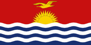
| Flag | Kiribati Flag |
|---|---|
| Country | Kiribati |
| Capital | Tarawa |
| Continent | Oceania |
| Official Languages | Kiribati and English |
| Currency | Australian Dollar (AUD) |
| Dialling Code | +686 |
Kiribati Flag Meaning
Flag Design
The Kiribati flag is rectangular with a 1:2 aspect ratio. The upper half is red, featuring a golden frigatebird in flight near the hoist, with a rising golden sun above it. The lower half is blue with three white wavy stripes alternating with three blue wavy stripes, representing the vast Pacific Ocean. The flag’s red, blue, white, and yellow colours create a simple yet distinctly island-inspired design.
Meaning
The red symbolises the land and the people, while the blue and white wavy lines represent the surrounding Pacific Ocean and its waves, reflecting Kiribati’s nature as a nation of scattered islands connected by the sea. The frigatebird, a key navigational symbol in traditional Kiribati seafaring culture, was used by fishermen to locate fish and is associated with freedom and guidance. The rising sun symbolises hope, renewal, and Kiribati’s position straddling the equator as one of the first nations to greet the new day. Together, these elements tell the story of a seafaring people living in harmony with the ocean and rooted in their island homes.
History and Legal Status
Before independence, Kiribati used the British colonial flag. In 1979, the year of independence, a national flag design competition was held, and the winning design featuring the frigatebird and rising sun was officially raised at the independence celebrations. The flag has been in continuous use since then and is prominently displayed during national events, at government buildings, schools, and on ships. The Kiribati people hold the flag in high regard, and visitors should behave respectfully in contexts involving the flag, national emblem, or anthem.
Kiribati Overview
Country Details »About Kiribati
Kiribati (the Republic of Kiribati) is a mid-Pacific island nation straddling the equator, composed of 33 atolls and coral islands grouped into three major island chains: the Gilbert Islands, Phoenix Islands, and Line Islands. Spread across approximately 3,800 kilometres east to west and 2,000 kilometres north to south, it is one of the most geographically dispersed countries in the world—and the only one that spans both the eastern and western hemispheres as well as the northern and southern hemispheres. The total land area is only about 811 square kilometres, but its exclusive economic maritime zone exceeds 3.5 million square kilometres—over four thousand times the size of its landmass.
The capital, South Tarawa, is located on the Tarawa Atoll in the Gilbert Islands. It consists of several small islands connected by causeways and serves as the country’s administrative, commercial, and transport hub. About half of the country’s population lives here. Kiribati has a population of around 120,000, the vast majority of whom belong to the Micronesian ethnic group known as I-Kiribati. The official languages are Kiribati and English, and Christianity is the predominant religion.
Geography and Climate
All of Kiribati’s islands are coral atolls or raised coral islands, with an average elevation of less than two metres and a highest point of just over ten metres, making it one of the countries with the lowest elevation in the world. The country is divided into three island groups: the Gilbert Islands in the west are the most populated; the central Phoenix Islands are largely uninhabited and remain pristine; the eastern Line Islands cross the International Date Line, including Kiritimati (also known as Christmas Island), which is the world’s largest coral atoll with a land area of about 388 square kilometres.
The climate is tropical maritime, hot and humid year-round, with temperatures typically ranging between 26–32°C. The months from May to October are influenced by southeast trade winds, making them relatively cooler and dryer. The rainy season runs from November to April, characterized by hot, humid weather and occasional tropical cyclones. Due to the extremely low elevation, tides, storm surges, and saltwater intrusion significantly affect daily life. Freshwater is mainly sourced from rainwater collection and underground freshwater lenses.
Historical Background
The earliest inhabitants of the Kiribati islands were seafaring peoples who migrated from Southeast Asia and Micronesia thousands of years ago, navigating the vast Pacific using outrigger canoes and celestial navigation. In 1606, Spanish navigator Pedro Fernandes de Queirós was the first European to record the region. In 1777, British explorer Captain James Cook arrived at Christmas Island. During the 19th century, whaling ships and copra traders arrived, integrating the islands into the global trade system.
In 1892, Britain declared the Gilbert Islands a protectorate, and in 1916 they were merged with the Ellice Islands (now Tuvalu) to form a single British colony. During World War II, Betio on Tarawa Atoll became the site of one of the Pacific War’s bloodiest amphibious assaults. The Battle of Tarawa in November 1943 left behind numerous bunkers, coastal artillery, and landing craft wrecks. On 12 July 1979, Kiribati gained independence, with its name derived from the local spelling of “Gilberts.” Since independence, the government has been a prominent voice internationally in advocating for climate change awareness.
Economy and Currency
Kiribati has a small and undiversified economy, relying primarily on copra exports, fishing license fees for tuna, remittances from overseas workers, and foreign aid. Banaba Island (formerly Ocean Island) was once prosperous due to phosphate mining, but after the depletion of resources, the island suffered severe ecological damage, and most residents relocated to Rabi Island in Fiji. In recent years, the government has earned significant revenue by selling fishing rights in its exclusive economic zone. Tourism remains underdeveloped.
Kiribati does not issue its own banknotes. The official currency is the Australian Dollar (AUD), issued by the Reserve Bank of Australia. Kiribati also mints its own coins, called Kiribati Dollars, which are equal in value to Australian Dollars but circulate only domestically. With very few financial institutions and extremely limited card payment acceptance, travellers will need to rely almost entirely on cash in Kiribati. Be sure to carry sufficient Australian Dollar banknotes from Australia or Fiji before arrival.
Culture and Society
Kiribati people refer to themselves as I-Kiribati, and the society maintains strong traditions of family and village community. Each village typically has a maneaba—a communal meeting hall that serves as a centre for gatherings, meetings, dancing, and hosting guests. Shoes must be removed upon entry, and seating follows a hierarchical order based on age. Traditional dance and song play important roles in social life, and handmade woven mats and shark tooth weapons are notable crafts.
Because of its low-lying geography, Kiribati is considered one of the countries most directly threatened by rising sea levels. The government has long advocated for international emission reductions and has purchased about 2,000 hectares of land in Fiji to ensure food security and as a potential relocation site in extreme scenarios. Locals continue to reinforce seawalls and plant mangroves to protect their ancestral homes.
Tourism Overview
Kiribati is not a developed tourist destination, which helps preserve its remarkably pristine island landscapes. World War II relics, coconut groves, and lagoons on Tarawa Atoll appeal to history enthusiasts and snorkellers. Christmas Island offers world-class bonefish fly fishing and abundant seabird breeding grounds. The Phoenix Islands Protected Area, established in 2008 and designated a UNESCO World Heritage Site in 2010, is one of the largest marine protected areas on Earth, largely untouched by human activity.
It is important to note that international flights to Kiribati are very limited, inter-island travel relies on weekly or even bi-weekly flights and irregular cargo ships, and accommodation and dining options on outer islands are very basic. Delays of several days due to weather or mechanical issues are not uncommon. This destination is suitable for experienced, physically fit, and time-flexible travellers who are comfortable with simple conditions. Be sure to double-check flight and accommodation arrangements in advance, and allow ample buffer time for each leg of your journey.
Kiribati Travel Guide
All Guides »Kiribati Travel Quick Guide: Visa-Free Entry, Best Time to Visit, Budget & Island Etiquette
Before you go, make sure you understand visa-free entry rules, the best travel s...
Kiribati 7-Day Classic Itinerary: Tarawa WWII Sites and Christmas Island Atoll 7 days
Connect the Gilbert Islands’ Tarawa with the Line Islands’ Christmas Island for ...
4-Day Short Trip in Kiribati: Island-Hopping from South to North in Tarawa Atoll 4 Days
Even with just four days, there’s no need to worry. By dividing the trip into se...
A must-visit list of Kiribati attractions: From Betio Battlefield to the Phoenix Islands Protected Area
Explore Kiribati’s most noteworthy natural and historical sites by island group,...
Kiribati Cuisine and Food Guide: Coconut Fish, Coconut Crab, and Island Staples
Island cuisine based on the sea and coconut groves features fresh fish, coconut ...
Travel Guide to Getting Around Kiribati: International Connections, Inter-Island Flights, and Local Transport
Few international flights, irregular inter-island ferry schedules, and limited a...