St. Vincent and the Grenadines Flag
The proportions, colors, and history of St. Vincent and the Grenadines's flag - a banner that tells St. Vincent and the Grenadines's own story.
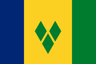
| Flag | St. Vincent and the Grenadines Flag |
|---|---|
| Country | St. Vincent and the Grenadines |
| Capital | Kingstown |
| Continent | North America |
| Official Languages | English |
| Currency | East Caribbean Dollar (XCD) |
| Dialling Code | +1784 |
St. Vincent and the Grenadines Flag Meaning
Flag Design
The flag of Saint Vincent and the Grenadines is rectangular, with a width-to-length ratio of approximately 2:3. The flag consists of three equal horizontal bands of blue, yellow, and green from top to bottom. The central yellow band features three green rhombuses (diamond shapes) arranged in a “V” formation, representing the first letter of the country’s name, Saint Vincent, and also referred to as the “Gems,” symbolizing the country as a jewel in the Caribbean Sea.
Meaning
Blue represents the sky and the surrounding Caribbean Sea and Atlantic Ocean, yellow symbolizes sunlight and golden sandy beaches, and green stands for lush vegetation and fertile agricultural land. The three horizontal bands represent the “sea, beach, and mountains,” providing a simple yet vivid summary of the country. The three green rhombuses not only form the letter “V” for Saint Vincent but also symbolize the Grenadine islands scattered like gems across the blue sea. The rhombuses are also said to resemble the leaves of the arrowroot plant, a local specialty, reflecting the country’s natural wealth and foundation.
History and Legal Status
The current flag was adopted on October 27, 1979, the day of the country’s independence, replacing the colonial Blue Ensign. It was finalized with input from local designers. The original version featured blue rhombuses at the center, which were officially changed to green in 1985 and have remained so ever since. The color and proportion standards were published in the government gazette, giving the flag clear legal status. The flag is prominently displayed nationwide on Independence Day, October 27, particularly at government buildings, schools, and port vessels in Kingstown. Due to its simple and striking design, it is also widely seen at sailing events and tourism promotional materials on Bequia Island, becoming a familiar Caribbean symbol for island-hoppers.
St. Vincent and the Grenadines Overview
Country Details »Overview of Saint Vincent and the Grenadines
Saint Vincent and the Grenadines is located at the southern end of the Windward Islands in the Lesser Antilles of the eastern Caribbean Sea. It consists of the main island of Saint Vincent and a string of smaller islands to the south (the northern part of the Grenadines). The country covers an area of approximately 389 square kilometers, with a population of about 100,000. Its capital, Kingstown, is situated on the southwestern coast of Saint Vincent. The country gained independence from the United Kingdom on October 27, 1979, and is a member of the Commonwealth and the United Nations. It operates under a parliamentary system, and its official language is English.
Despite its small size, the country boasts some of the Caribbean’s most renowned sailing and island-hopping waters. The islands of Bequia, Mustique, Canouan, Mayreau, and Union Island are lined up in a row, while the crescent-shaped reef of Tobago Cays Marine Park is a mecca for sailors and fans of *Pirates of the Caribbean*.
Geography and Climate
The main island of Saint Vincent is a volcanic island, approximately 29 kilometers long from north to south. In the central-northern part stands the active stratovolcano La Soufrière, which rises 1,234 meters above sea level and is the country’s highest point. The island features deeply cut streams, numerous waterfalls, and predominantly black volcanic sandy beaches along the coast. The eastern coast is windy and rough, while the western leeward side is calmer and suitable for anchoring. The smaller Grenadine islands have low-lying terrain, surrounded by coral reefs, with waters that transition from light green to deep blue, making them world-class anchorages and snorkeling spots.
The climate is tropical maritime, with temperatures ranging from 24 to 30 degrees Celsius year-round. The dry season from January to May features stable trade winds, making it the peak sailing and tourist season. The rainy season and hurricane season span from June to November. In April 2021, La Soufrière volcano erupted violently several times, leading to the emergency evacuation of around 20,000 residents and severe damage to the northern part of the main island. Since then, post-disaster reconstruction and tourism recovery have continued, with major tourist areas located in the southern part of the main island and the Grenadines, which were minimally affected by the volcano.
Historical Background
Saint Vincent was recorded by Europeans during Christopher Columbus’s third voyage in 1498. However, due to the resistance of the indigenous Kalinago people, European colonial powers were unable to establish a foothold for a long time until the 18th century when Britain and France repeatedly contested the island. After the Treaty of Versailles in 1783, the island came under British control, and some of the indigenous people were relocated to Central America. Following the abolition of slavery in 1834, Portuguese and East Indian indentured laborers arrived, forming today’s society, which is predominantly of African descent with mixed European and Asian ancestry. Internal self-government was granted in 1969, and the country gained full independence on October 27, 1979.
Since independence, the country has been primarily agriculture-based, with bananas and arrowroot serving as key exports. Arrowroot starch has been exported globally since the 19th century and remains a flagship agricultural product of “Made in Saint Vincent.” The 2021 volcanic eruption was the most severe natural disaster in the country’s independent history, with international aid and remittances supporting the reconstruction of northern communities.
Economy and Currency
The economy is based on agriculture (bananas, arrowroot, taro), fishing, tourism, and small-scale offshore services. In recent years, the focus has shifted toward high-end tourism and the yacht economy. Mustique Island is known for its celebrity private holiday villas, while Canouan Island has seen the development of resorts and a private airport. The official currency is the East Caribbean Dollar (XCD), which is pegged at a fixed rate of 2.7 to 1 US dollar and issued by the Eastern Caribbean Central Bank. It is used across the Eastern Caribbean Currency Union, including Dominica, Saint Lucia, Grenada, and other member states.
Culture and Society
The population is predominantly of African descent, and English is the official language, though Vincentian Creole English is commonly spoken. The Vincy Mas festival, held annually in June and July, is part of the Caribbean carnival season, featuring soca music and steelpan bands that play through the night. Bequia Island’s tradition of small boat building and whaling (now strictly regulated by international conventions) has shaped a unique island craftsmanship culture. The country has also gained recognition in the Caribbean arts scene with locally produced works such as the Oscar-nominated film *Milk and Honey* and various art projects by painters and writers.
Tourism Overview
The tourism experience in Saint Vincent and the Grenadines is divided into two parts: the main island is ideal for volcano hiking (such as climbing the crater of La Soufrière), visiting the oldest botanical garden in the Western Hemisphere (established in 1765), and relaxing on black sand beaches. The Grenadines, on the other hand, are a true island-hopping paradise. Visitors can charter sailboats or take inter-island ferries from Kingstown or Bequia, exploring each island in turn. Snorkel in the unspoiled waters of Tobago Cays to see turtles and coral, or watch kiteboarding in the horseshoe-shaped lagoon of Union Island. Several scenes from the first *Pirates of the Caribbean* movie were filmed here, and visitors can still sail in the same crystal-clear waters and white sands.
St. Vincent and the Grenadines Travel Guide
All Guides »Saint Vincent and the Grenadines Travel Preview: Visa, Seasons, Budget, and Island-Hopping Essentials
How to Get the Most Out of a Sailing Paradise: Visa Options, Dry Season Sailing ...
Classic 7-day island-hopping itinerary in Saint Vincent and the Grenadines: Main Island – Bequia – Tobago Cays – Union Island 7 days
Journey south from the volcanic main island to a sailor’s paradise: hike, sail, ...
Saint Vincent and the Grenadines 4-Day Short Trip: Highlights of Bequia and Tobago Cays 4 days
Skip the main island and head straight to the southern isles: experience Bequia’...
Must-visit attractions in Saint Vincent and the Grenadines: Tobago Cays, Bequia, and the volcano
Two main sections: hiking on the main volcanic island and island-hopping in the ...
Saint Vincent and the Grenadines Food Guide: Seafood, Breadfruit, and Rum Under the Stars
Island-Hopping Dining Guide: Fresh Grilled Fish, National Breadfruit Dishes, Tar...
Complete Guide to Transportation in Saint Vincent and the Grenadines: Connecting Flights, Island Ferries & Charter Boats
How to make connecting flights, check island ferry schedules, share sailing char...