Nauru Flag
The proportions, colors, and history of Nauru's flag - a banner that tells Nauru's own story.
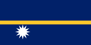
| Flag | Nauru Flag |
|---|---|
| Country | Nauru |
| Capital | Yaren (seat of government) |
| Continent | Oceania |
| Official Languages | Nauruan, English |
| Currency | Australian Dollar (AUD) |
| Dialling Code | +674 |
Nauru Flag Meaning
Flag Design
The Nauru flag is rectangular, with a 1:2 aspect ratio. The field is dark blue, with a golden horizontal stripe across the center. Below and slightly left of the stripe is a white twelve-pointed star. The flag uses only blue, yellow, and white, with a simple yet highly recognizable design.
The yellow stripe and the twelve-pointed star are not centrally aligned: the yellow band divides the blue field into upper and lower halves, with the white star positioned below the stripe, immediately conveying orientation. The large blue background highlights the brightness of the yellow and the prominence of the white star, giving the flag a unique color scheme among Pacific island nations.
Meaning
The deep blue represents the vast Pacific Ocean surrounding Nauru; the golden stripe symbolizes the equator and also evokes the phosphate deposits vital to Nauru’s economy. The white twelve-pointed star stands for the twelve traditional clans, positioned beneath the yellow stripe to indicate Nauru’s location south of the equator. Thus, the flag encapsulates the country’s geography, clans, and resource history in a single visual, making it one of the most symbolic flags among Pacific island nations.
History and Legal Status
Before independence, Nauru was under the administration of Germany, Britain, and Australia, using various official flags. Upon gaining independence in 1968, Nauru officially adopted its current flag, which has remained in use ever since. It is displayed on Independence Day, national celebrations, government buildings, schools, and vessels. The design and colors have not changed since independence and are seen as symbols of national stability and clan unity. Nauruans hold their flag and tribal traditions in high regard, and visitors should behave respectfully at official or community events, avoiding any disrespect toward national symbols such as the flag or emblem.
Nauru Overview
Country Details »Nauru Overview
Nauru (officially the Republic of Nauru) is a single coral island nation located in the central-western Pacific Ocean, about 42 kilometers south of the equator. With a land area of just 21 square kilometers, it is the world’s smallest island country and also the smallest republic globally. The island is oval-shaped, with a coastline of approximately 30 kilometers. A ring road almost connects all accessible areas of the island. Nauru does not have an official capital, but government offices and main institutions are concentrated in the Yaren District in the southwest, which is often considered the de facto administrative center.
Nauru has a population of about 12,000, predominantly Nauruan, along with residents from other Pacific islands and Asia. The official languages are Nauruan and English, with English widely used in administrative and business settings. Despite its small size, the country has frequently gained international attention due to its history of phosphate mining, unique international status, and recent regional affairs.
Geography and Climate
Nauru is a raised coral island with a central plateau elevated several dozen meters above sea level, locally called Topside, surrounded by narrow coastal lowlands. The phosphate mines in the island’s center, intensively mined for nearly a century, have created a distinctive landscape of limestone pillars and pitted craters resembling the surface of the moon—this is Nauru’s most iconic sight. The highest point, Command Ridge, once hosted military facilities during World War II, with remnants still visible today. There are no rivers on the island; freshwater is sourced from a desalination plant and rainwater collection.
The climate is tropical maritime, with high temperatures year-round, typically ranging between 26–32°C, and high humidity. The rainy season occurs from November to February, with concentrated rainfall, while March to October is drier. Due to the island’s small size and low elevation, Nauru faces environmental challenges such as coastal erosion, sea-level rise, and freshwater scarcity.
Historical Background
The earliest inhabitants of Nauru were seafaring peoples from Micronesia and Polynesia, traditionally divided into twelve clans, which inspired the twelve-pointed star on the national flag. In 1798, British captain John Fearn arrived and named it Pleasant Island. By the late 19th century, Germany incorporated Nauru into its Pacific territories. In 1900, high-grade phosphate deposits were discovered and subsequently mined by British, German, and Australian interests.
After World War I, Nauru came under a League of Nations mandate administered by Australia, New Zealand, and the United Kingdom. During World War II, it was occupied by Japan, which built an airfield and fortifications, and residents endured significant hardship. In 1947, the United Nations placed Nauru under the joint trusteeship of Australia, New Zealand, and the UK. On January 31, 1968, Nauru became an independent nation, one of the earlier Pacific island countries to do so. Starting in the 1970s, Nauru directly managed its phosphate resources and briefly ranked among the world’s highest per capita income nations. As phosphate reserves declined and the economy weakened, the country sought new revenue sources such as fisheries, trust funds, and international cooperation.
Economy and Currency
Following the depletion of phosphate resources, Nauru faced prolonged economic difficulties. Today, its economy relies mainly on fishing license fees, regional cooperation projects, financial trust revenues, and foreign aid. Due to the rich tuna stocks in surrounding waters, Nauru is a member of the Nauru Agreement, gaining significant fiscal revenue through collectively managed fishing rights. The island’s port, a deep-water facility, is crucial for fishing vessel supply and cargo movement.
Under an agreement with Australia, Nauru hosts an Australian Regional Processing Centre for asylum seekers arriving by sea. This arrangement is both important and controversial, being a longstanding intergovernmental agreement subject to policy changes, though it generally does not affect travelers. Understanding this context helps provide insight into the local society and public sentiment.
Nauru has no national currency; the legal tender is the Australian Dollar (AUD), used for virtually all cash transactions. Banks and places accepting foreign cards are extremely limited, so it is essential to bring sufficient cash when traveling to Nauru.
Culture and Society
Nauruan society is based on the twelve traditional clans, with strong family and village ties. Clan identity remains culturally significant. Traditional dances, songs, and fishing skills are preserved, and coconut trees and island life shape unique cuisine and customs. Both English and Nauruan are spoken, with younger generations generally fluent in English. Due to fluctuating national finances, Nauruan society is highly reliant on external economic support and regional cooperation.
The pace of life is relaxed, and community activities often revolve around churches, schools, and sports. Australian Rules Football is especially popular and is one of the most followed sports. October 26 marks Angam Day, commemorating two historical occasions when the population recovered from lows, and is Nauru’s most significant national holiday.
Tourism Overview
Nauru is not a conventional tourist destination, with limited accommodation and few dining or shopping options. There are no typical beach resorts. Its appeal lies in its unique phosphate mining landscapes, the island’s ring road hiking trail, the coastal views of Anibare Bay, the greenery of Buada Lagoon, as well as WWII remnants and insights into the rise and decline of a small island nation.
Travelers can spend a day driving or walking the ring road to experience how a small country reshaped by mining operates within its confined space. Due to very limited international flights and strict logistical constraints, Nauru is best suited for in-depth travelers with a specific interest in Pacific island nations’ politics, economy, and geography. Pre-trip planning should carefully confirm flights, permits, and accommodations.
Nauru Travel Guide
All Guides »Nauru Travel Quick Guide: Visa Requirements, Best Time to Visit, Budget Tips, and Island Etiquette
It’s a small country you can drive around in an afternoon, but before you go, ma...
Nauru 7-Day Classic Itinerary: Island Circumnavigation and Central Phosphate Pit Landscapes 7 Days
Spend a week slowly exploring the world’s smallest island nation, taking in its ...
4-Day Short Trip in Nauru: A Three-Tier Exploration of Coastline, Phosphate Plateaus, and Lagoons 4 days
Don’t worry if you only have four days — this itinerary is structured across thr...
Complete list of must-visit attractions in Nauru: Anibare Bay and phosphate mining landscapes
From expansive bays and the only freshwater lake to mining terraces and WWII rel...
Nauru Food and Dining Guide: Coconut Fish, Coconut Crab, and Island Home Flavors
Although the island imports most of its food, its dining table still retains the...
Nauru Travel Transport Guide: Flight Connections, Island Roads, and Left-Hand Driving Rules
On an island with just one or two international flights per week, transport tran...