Eritrea Flag
The proportions, colors, and history of Eritrea's flag - a banner that tells Eritrea's own story.
| Flag | Eritrea Flag |
|---|---|
| Country | Eritrea |
| Capital | Asmara |
| Continent | Africa |
| Official Languages | Tigrinya, Arabic, English |
| Currency | Eritrean nakfa (ERN) |
| Dialling Code | +291 |
Eritrea Flag Meaning
Flag Design
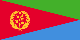
The Eritrean flag is a 1:2 ratio rectangle divided into three triangles: a green triangle at the top, a blue triangle at the bottom, separated by a diagonal line, and a red equilateral triangle along the hoist side, featuring a golden olive wreath in the center. The design is simple yet striking, making it one of Africa’s most recognizable national flags.
Meaning
Green symbolizes the country’s agriculture and fertile highlands, representing the land and hope sustaining its people. Blue stands for the Red Sea, reflecting Eritrea’s deep historical and geographical ties to the ocean. Red commemorates the blood shed during the 30-year armed struggle for independence, with the red triangle extending from the hoist to the center, signifying the path to freedom. The golden olive wreath embodies peace and dignity, as well as the aspiration for unity among Eritrea’s diverse ethnic groups.
History and Legal Status
The current flag was officially adopted on May 24, 1993, the day of Eritrea’s independence. The olive wreath design dates back to the 1952 flag during Eritrea’s autonomous period, which was inspired by the United Nations’ olive branch symbolism, representing peace under UN supervision. The 1952 and 1993 flags share a direct visual lineage, a rare continuity spanning over 40 years among African nations. Flag laws mandate its display at government buildings, schools, border crossings, and during Independence Day (May 24) celebrations, with strict regulations against misuse. Avoid handling or damaging items bearing the flag.
Eritrea Overview
Country Details »Eritrea Overview
Eritrea is located in northeastern Africa along the western coast of the Red Sea, bordered by Sudan to the north, Ethiopia to the west, Djibouti to the southeast, and facing Yemen across the Red Sea. With a coastline stretching about 1,900 kilometers, it is a strategic gateway to the Red Sea and the Mandeb Strait. The country covers approximately 117,600 square kilometers, with its capital, Asmara, situated over 2,300 meters above sea level on the central highlands. Asmara enjoys a cool and pleasant climate and serves as the national political and cultural center.
Eritrea has a population of about 3.7 million, with the Tigrinya and Tigre peoples as the main ethnic groups. The official languages are Tigrinya, Arabic, and English. The country gained independence through a referendum in 1993 and is one of Africa’s youngest nations. Its current political system is highly centralized, and its social and economic openness remains low compared to other African countries.
Geography and Climate
Eritrea’s terrain is divided into three levels: the narrow Red Sea coastal plain in the east, which is hot and arid; the central highlands, an extension of the East African Rift and Ethiopian Highlands, where agriculture and population are concentrated; and the western region, which transitions toward the Sudanese plains and Danakil Depression. The southeastern Danakil extension is one of the hottest and driest areas on Earth. The country lacks perennial major rivers, and water resources are extremely limited.
The climate varies significantly with altitude: highland cities like Asmara remain cool year-round with large diurnal temperature variations, while Red Sea ports such as Massawa experience extreme hot and dry conditions, with summer temperatures often exceeding 40°C, making it one of the hottest coastal cities globally. The rainy season is concentrated in June–August, with precipitation mainly occurring in the highlands.
Historical Background
Eritrea’s coastal region has long been a key node in Red Sea trade, with close ties to the Arabian Peninsula since the Aksumite Kingdom era. From the 16th century, the Ottoman Empire and Egypt successively ruled the coastal areas. By the late 19th century, Italian colonizers gradually expanded their control, and in 1890, the colony of "Eritrea" was officially established, with Asmara developed into one of Africa’s most modernized cities at the time. After Italy’s defeat in 1941, Britain briefly administered the territory, and in 1952, the United Nations federated it with Ethiopia. The federation was dissolved in 1962.
From 1961, the Eritrean People’s Liberation Forces waged a 30-year armed struggle, gaining control of the entire territory by 1991. Eritrea officially gained independence in 1993 following a UN-supervised referendum. A border war with Ethiopia resumed in 1998–2000, leading to prolonged tensions and a shift toward inward-focused governance. Relations between the two countries normalized in 2018.
Economy and Currency
Eritrea’s economy relies on agriculture, mining, and remittances. Gold, copper, and zinc mines have seen gradual development in recent years, and the Red Sea offers rich but underutilized fishing resources. Due to long-standing restrictions and sanctions, the economy has low openness, and the private sector remains weak. The official currency is the nakfa (ERN), introduced in 1997 with a strictly fixed official exchange rate. Foreign currency exchange is tightly regulated, international bank cards are largely unusable, and travelers must rely on cash foreign currency exchanged through designated channels.
Culture and Society
Eritrea is home to nine major ethnic groups, with Tigrinya culture as the dominant influence. Christianity and Islam coexist. The Italian colonial legacy left a lasting coffee culture: espresso bars line Asmara’s streets, where people often sit outdoors sipping macchiato in the afternoon. War memories have shaped a strong national identity, reflected in sites like Nakfa town, Independence Day celebrations, and war memorials.
Tourism Overview
Eritrea boasts unique tourism assets in Africa: Asmara, known as the "African City of Modernism," was inscribed as a UNESCO World Heritage Site in 2017, with well-preserved Bauhaus and Art Deco-style cinemas, gas stations, and churches. Massawa’s old town features Ottoman-era Red Sea architecture, and the Dahlak Archipelago offers significant coral reef diving potential. The railway and historic cable car from Asmara to Massawa are engineering marvels.
However, Eritrea’s security situation and travel restrictions severely impact tourism. Even with entry permission, foreign travelers typically need advance authorization to leave the capital and must rely almost entirely on licensed travel agencies for arrangements. Always verify the latest consular alerts and entry policies before traveling.
Eritrea Travel Guide
All Guides »Eritrea Travel Quick Guide: Safety Alerts, Visa Requirements, Seasons & Budget
Traveling to Eritrea is unlike visiting most other countries: safety alerts, tra...
Eritrea 7-Day Itinerary: Asmara – Keren – Massawa – Dahlak 7 days
Classic route within permitted and safe areas: modernist highland capital, mount...
4-Day Eritrea Short Trip: Asmara In-Depth and Red Sea Descent 4 Days
When time is limited, focus on two highlights: immerse yourself in Asmara’s arch...
Essential Attractions in Eritrea: A Modernist City and Red Sea Coral
UNESCO-listed architecture in Asmara, the historic old town of Massawa, and the ...
Eritrea Food Guide: Injera, Red Sea Seafood & Espresso
Tigrinya cuisine, Italian colonial legacy, and Red Sea catches create one of Afr...
Eritrea Transport Guide: Permits, Long-Distance Buses, and the Red Sea Railway
In Eritrea, the key to travel planning isn’t buying tickets—it’s securing permit...