Guyana Flag
The proportions, colors, and history of Guyana's flag - a banner that tells Guyana's own story.
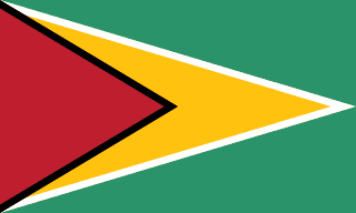
| Flag | Guyana Flag |
|---|---|
| Country | Guyana |
| Capital | Georgetown |
| Continent | South America |
| Official Languages | English |
| Currency | Guyanese dollar (GYD) |
| Dialling Code | +592 |
Guyana Flag Meaning
Flag Design
The flag of Guyana, commonly known as the “Golden Arrowhead,” was officially adopted on Independence Day, May 26, 1966. It was designed by American vexillologist Whitney Smith. The flag is a green rectangle with a 3:5 ratio. On the hoist side, a golden (yellow) isosceles triangle points toward the fly end, bordered by white and then black edges. Within the golden arrow is a red isosceles triangle pointing in the same direction, outlined in black. The flag uses five colors: green, white, gold, black, and red.
Meaning
Each color has symbolic meaning: green represents Guyana’s rich agriculture and forests, the golden arrow symbolizes the country’s mineral wealth and bright future, red stands for the people’s zeal and energy in building the nation, black signifies the resilience and endurance of the Guyanese people, and white represents the rivers and water resources. The arrow shape reflects both Guyana’s identity as the “land of many waters” and the nation’s forward-looking aspirations.
History and Legal Status
Before independence in 1966, Guyana, as a British colony, used the British Blue Ensign with a colonial emblem. Upon independence, the government held a public competition for a new flag design, and Smith’s Golden Arrowhead was selected. The original design lacked the black and white borders, which were later added on the advice of the College of Arms in the UK to enhance clarity. Today, the Golden Arrowhead is widely used at government buildings, schools, sporting events, and national celebrations, serving as a key symbol of national identity. Variants are also used for the naval and presidential flags.
Guyana Overview
Country Details »About Guyana
Guyana (officially the Co-operative Republic of Guyana) is located in the northeastern part of South America, bordering the Atlantic Ocean to the north, Suriname to the east, Venezuela to the west, and Brazil to the south. It covers an area of approximately 215,000 square kilometers. As the only English-speaking country in South America, it has a population of about 800,000, with its capital, Georgetown, situated at the mouth of the Demerara River and home to nearly half of the country’s population. Geographically and culturally closer to the Caribbean, Guyana is a member of the Caribbean Community (CARICOM), and the Guyanese Creole language, with a Caribbean accent, is widely spoken in daily life.
The word “Co-operative” in Guyana’s official name originates from the cooperative socialist ideals promoted when the republic was established in 1970. The country consists of coastal plains, white sand belts, inland plateaus, and southern savannahs. A highly diverse society is formed by Indo-Guyanese, Afro-Guyanese, Indigenous peoples, mixed-race individuals, as well as Chinese and Portuguese descendants.
Geography and Climate
Guyana’s terrain is roughly divided into four zones from north to south: the Atlantic coastal plain (where about 90% of the population lives, with much of the land below sea level and protected by dikes and drainage canals built during Dutch colonial times), the white sand belt, the inland plateau, and the southern Rupununi savannah. Major rivers include the Essequibo (Guyana’s longest river), the Demerara, the Berbice, and the Corentyne. Mount Roraima, a flat-topped tepui in the Pakaraima Mountains reaching about 2,810 meters, is Guyana’s highest peak. Its tabletop mountains are believed to have inspired Sir Arthur Conan Doyle’s novel The Lost World.
The climate is tropical rainforest and tropical savannah, characterized by high temperatures and humidity year-round, with average annual temperatures of 24–32°C. There are two rainy seasons annually (mid-May to mid-July and mid-November to mid-January). The inland rainforest receives abundant rainfall, while the southern Rupununi savannah is better suited for travel during the dry season (around September to March).
Historical Background
Guyana’s coastal and inland regions have been inhabited for tens of thousands of years by Indigenous peoples such as the Arawak, Carib, Makushi, and Wapishana, whose descendants still make up about 10% of the population. In the 17th century, the Dutch established three colonies—Essequibo, Demerara, and Berbice—digging dikes and canals to develop sugarcane plantations. Between 1814 and 1815, these territories were officially ceded to Britain and merged into British Guiana in 1831. After slavery was abolished in 1834, plantation owners brought indentured laborers from India, China, Portugal, and other regions. Starting in the 1840s, large numbers of South Asian immigrants arrived, profoundly shaping the current demographic makeup.
On May 26, 1966, Guyana gained independence from Britain, becoming the first former British colony on the South American mainland to do so. It became a cooperative republic in 1970. Post-independence politics were long influenced by ethnic divisions, and the economy experienced periods of stagnation. In 2015, significant offshore oil reserves were discovered in the Stabroek Block, with production starting in 2019, making Guyana one of the fastest-growing emerging economies in the world in recent years. There is an ongoing territorial dispute with Venezuela over the Essequibo region, currently under consideration by the International Court of Justice.
Economy and Currency
Traditionally, Guyana’s economy was based on sugarcane, rice, bauxite, gold, and timber. The discovery and extraction of offshore oil are rapidly transforming the nation’s fiscal situation and industrial structure, significantly raising per capita income and updating the urban landscape of Georgetown. The official currency is the Guyanese dollar (GYD, symbol G$), issued by the Bank of Guyana. The exchange rate with the US dollar has remained relatively stable. While the US dollar is not the official currency, it is widely accepted in hotels, travel agencies, and for major purchases.
Culture and Society
Guyanese society is a mosaic of diverse ethnic groups: Indo-Guyanese make up about 40%, Afro-Guyanese about 30%, with mixed-race and Indigenous peoples also comprising significant portions, along with Chinese and Portuguese communities. Religiously, Hinduism, Christianity, Islam, and indigenous beliefs coexist, with temples, mosques, and churches often found in the same neighborhoods. Cricket is the national sport, and the national team competes as part of the West Indies. The cuisine is a blend of Creole, Indian, African, and British influences, with pepperpot, cook-up rice, and roti with curry being among the most iconic dishes. Mashramani, a massive carnival held on February 23 to celebrate Republic Day, is the country’s largest festival.
Tourism Overview
The heart of Guyanese travel lies inland: Kaieteur Falls is famed for its approximately 226-meter single-drop height and abundant water flow, accessible only by small aircraft; the Iwokrama Rainforest Reserve features a 30-meter-high canopy walkway, ideal for spotting jaguars, harpy eagles, and giant otters; the southern Rupununi savannah and nearby Makushi and Wapishana Indigenous communities offer horseback riding, stargazing, and eco-lodges; Shell Beach on the Atlantic coast is a nesting site for sea turtles like the leatherback. Georgetown’s wooden colonial architecture (such as St. George’s Cathedral, Stabroek Market, and City Hall) and seaside sunsets form the backbone of city sightseeing. It’s important to note that inland travel mainly relies on small aircraft and 4x4 vehicles, which can be costly and involve relatively basic infrastructure. Some areas of Georgetown have safety concerns, so it’s advisable to arrange travel plans through licensed local tour operators.
Guyana Travel Guide
All Guides »Guyana Travel Quick Guide: Visa, Seasons, Budget & Rainforest Interior Travel Essentials
Before traveling to Guyana, it’s important to understand the visa requirements, ...
Classic 7-Day Guyana Itinerary: Georgetown – Kaieteur – Iwokrama – Rupununi 7 days
Starting from a wooden colonial old town, flying over pristine rainforests to se...
Guyana 4-Day Short Trip: Highlights of Georgetown and the Surrounding Areas 4 days
Even with limited time, you can experience Guyana by using Georgetown as your ba...
Must-visit Attractions in Guyana: From Kaieteur Falls to the Rupununi Savanna
A region-by-region guide to the best natural and cultural sites in Guyana, with ...
Guyana Food Guide: Pepperpot, Cook-Up Rice, and Curry Roti
Guyanese cuisine is a melting pot of Creole, Indian, African, and British flavor...
Guyana Travel Guide: Small Planes, Inland Tours, and Getting Around Town
Inland Guyana has almost no highways, so it’s essential to understand your optio...