Lesotho Flag
The proportions, colors, and history of Lesotho's flag - a banner that tells Lesotho's own story.
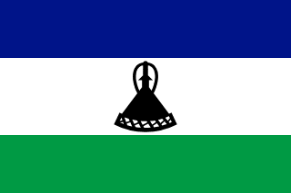
| Flag | Lesotho Flag |
|---|---|
| Country | Lesotho |
| Capital | Maseru |
| Continent | Africa |
| Official Languages | Sesotho, English |
| Currency | Lesotho loti (LSL) |
| Dialling Code | +266 |
Lesotho Flag Meaning
Flag Design
The national flag of Lesotho is a horizontal rectangle with a 2:3 aspect ratio, composed of three equal horizontal stripes in blue, white, and green. A black Basotho conical hat (mokorotlo) is featured in the centre of the white stripe. The hat, with its tall, slightly upturned conical shape, is the flag’s only graphic element, making the Lesotho flag one of the few in the world where a “hat” serves as the central emblem.
Meaning
Blue represents the sky and rain – essential for a country reliant on highland water and agriculture; white stands for peace; green symbolises fertile land and agricultural prosperity. The black hat is a core symbol of Basotho heritage, set against the white stripe to signify cultural identity and continuity. The hat also appears at royal coronations and national ceremonies, serving both as traditional dress and a spiritual emblem.
History and Legal Status
The current flag was adopted on October 4, 2006, the 40th anniversary of independence, replacing the previous military-era flag featuring diagonal white and blue bands with a shield and spear. The original 1966 independence flag also included a hat motif, and the new design is seen as a return to founding traditions. The flag is widely displayed on Independence Day (October 4), during parliamentary openings, and at sporting events. Government buildings, border posts, and schools are required to fly it. The hat design is also used on vehicle licence plates, national airline branding, and tourism promotions, becoming one of the most recognisable visual symbols of the Basotho people.
Lesotho Overview
Country Details »About Lesotho
Lesotho (officially the Kingdom of Lesotho) is located on the eastern plateau of southern Africa, entirely surrounded by South Africa. It is the world’s largest enclave and one of the few sovereign nations entirely within the borders of another country. Covering an area of about 30,400 square kilometres with a population of around 2.3 million, it is a constitutional monarchy with the king as head of state. The capital, Maseru, lies on the eastern bank of the Caledon River in the western border region, facing the South African town of Ficksburg across the river.
Lesotho is most famously known as the “Kingdom in the Sky”: it is the only country in the world where the entire territory lies above 1,000 metres in elevation. Its lowest point, at the confluence of the Orange and Makhaleng Rivers, is about 1,400 metres above sea level – making even this “lowest point” higher than the highest points of many other countries. The highland mountains offer a travel experience quite unlike the typical African stereotype.
Geography and Climate
The country consists mainly of the southern ranges of the Maloti and Drakensberg mountain ranges, with about 80% of the land being mountainous or highland. The highest peak, Thabana Ntlenyana (3,482 metres), is the tallest in southern Africa and the source of the Orange River. The Lesotho Highlands Water Project (LHWP) diverts highland water into massive reservoirs such as the Katse Dam, supplying clean hydroelectric power to South Africa – it is the country’s most important resource project.
The climate is a highland mountain type: Maseru, at about 1,600 metres elevation, has mild, thundery summers (October to March); winters (June to August) are harsh in the mountains, with frequent heavy snow above 2,500 metres and frequent closures of mountain pass roads. The Afriski Ski Resort in the eastern highlands is one of only two ski resorts in Africa.
Historical Background
In the early 19th century, expansion by the Zulu Kingdom caused great upheaval in southern Africa. Moshoeshoe I, a Basotho chief, built a stronghold on Thaba-Bosiu Mountain and united various clans, laying the foundation for the Basotho nation and successfully repelling attacks from neighbouring groups. To avoid annexation by the Boers, in 1868 Moshoeshoe sought British protection, and the area became the British protectorate of Basutoland.
Lesotho declared independence on October 4, 1966, retaining its monarchical system. In the decades following independence, the country experienced political instability. In 1986, the military took control of the government, civilian rule was restored in 1993, and a stable parliamentary democracy gradually took shape after 2002. Moshoeshoe I remains revered as the father of the nation, and his tomb at Thaba-Bosiu is a national pilgrimage site.
Economy and Currency
The economy is highly dependent on South Africa: revenue from selling water from the highlands to South Africa, remittances from workers in South African mines, the garment manufacturing industry (mainly exporting to the United States), and diamond mining form the four main pillars. The official currency is the loti (plural: maloti, currency code: LSL), pegged 1:1 with the South African rand, which also circulates legally and in parallel within the country. For details, see the currency section.
Culture and Society
The most iconic symbols of Basotho culture are the conical grass hat (mokorotlo) and the Basotho blanket: regardless of season, many people wear thick, patterned blankets instead of coats, with designs marking important life events. The hats, often featuring the national flag, have become a national symbol. Both Sesotho and English are official languages, most residents are Christian, and traditional rites of passage and the folk music genre famo are still practised.
Horses are a traditional mode of transport in the highlands, making pony trekking a signature travel experience in Lesotho: riding a sturdy Basotho pony along mountain ridge trails through valleys and villages reminiscent of the Scottish Highlands offers a unique experience you won’t find elsewhere.
Tourism Overview
Lesotho appeals to travellers who enjoy mountain adventures and self-drive exploration: a 4x4 journey over the Sani Pass from the KwaZulu-Natal side of South Africa leads to a bar at about 2,874 metres, claimed to be the highest in Africa; the 192-metre single-drop Maletsunyane Falls near Semonkong rank among the highest single-drop waterfalls in the world and offer commercial abseiling; the Sehlabathebe National Park preserves dinosaur footprints and natural stone arches; and the Katse Dam project and historical Thaba-Bosiu fortress add cultural depth.
Lesotho Travel Guide
All Guides »Lesotho Travel Snapshot: Enter via South Africa, High-Altitude Seasons, Budget & Basotho Etiquette
The key words for a Sky Kingdom trip are altitude and road conditions: get a qui...
Classic 6-Day Lesotho Itinerary: Fortresses, Waterfalls, and the Sani Pass Highland Loop 6 days
Enter and exit via Maseru, connecting the Thaba-Bosiu Fortress, a 192-meter wate...
Lesotho 4-Day Short Trip: History and Mountain Highlights Around Maseru 4 days
A three-part itinerary based in Maseru: historic fortresses, waterfall towns, an...
Must-Visit Attractions in Lesotho: From a 192-Meter Waterfall to the World’s Highest Bar
8 Core Experiences in the Kingdom in the Sky: Fortresses, Waterfalls, Dinosaur F...
Lesotho Food Guide: Maize Porridge with Stews, Highland Lamb, and Maluti Beer
The dining table of the Kingdom in the Sky is simple yet hearty: this guide cove...
Lesotho Travel Guide: Crossing via South Africa, Mountain Passes, 4WD Routes & Pony Trekking
From airport arrivals to four major border crossings, 4WD convoys, and pony trek...