Niger Flag
The proportions, colors, and history of Niger's flag - a banner that tells Niger's own story.
| Flag | Niger Flag |
|---|---|
| Country | Niger |
| Capital | Niamey |
| Continent | Africa |
| Official Languages | French |
| Currency | West African CFA franc (XOF) |
| Dialling Code | +227 |
Niger Flag Meaning
Flag Design
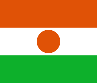
The flag of Niger consists of three equal horizontal bands of orange, white, and green, in that order from top to bottom, with an orange circle in the center of the white band. The flag has a 2:3 aspect ratio. The three horizontal stripes are simple and bold, with the central orange circle echoing the surrounding colors in a balanced composition. The flag was officially adopted in November 1959, before the country’s independence in 1960, and was one of the national symbols established during the pre-independence era.
Meaning
Orange represents the Sahelian savanna and the deserts of the northern Sahara, as well as hopes for the nation’s development. White symbolizes purity and integrity, and also reflects the Niger River that crosses the country. Green stands for the fertile lands, vitality, and hope of the southern part of the country. The orange circle in the center of the white band represents the sun, as well as the awakening and unity of the nation. Together, the three colors and the central sun symbolize this desert country’s reverence for sunlight, water, and harvest, encapsulating the natural environment of the Sahel and the ideals of the nation.
History and Legal Status
The flag of Niger was determined by the then-autonomous government in 1959 and retained after independence in 1960. It has undergone no fundamental changes since. The combination of the three horizontal bands and the central sun circle echoes the Pan-African colors used by many West African nations, but the unique central circle gives it a distinctive identity. Since independence, the flag has been enshrined in the constitution and related laws, and is widely displayed on National Day, at government buildings, schools, and border posts. Today, the orange, white, and green colors with the central sun have become Niger’s most prominent national symbols on the international stage, appearing on official documents, sports teams, and souvenirs.
Niger Overview
Country Details »Overview of Niger
Niger (officially the Republic of Niger) is a landlocked country in West Africa, located in the Sahel zone on the southern edge of the Sahara Desert. It borders Algeria and Libya to the north, Chad to the east, Nigeria and Benin to the south, and Burkina Faso and Mali to the west. The country covers an area of approximately 1.267 million square kilometers, making it one of the largest countries in West Africa. However, most of its territory consists of desert and semi-arid land. The capital, Niamey, is situated on the banks of the Niger River in the southwestern part of the country and serves as the political, economic, and cultural center. The official language is French, while Hausa, Zarma, and Tuareg are widely spoken among the populace.
The name Niger comes from the Niger River that runs through the country, which is also a vital lifeline for life and agriculture in the southern Sahel. With a population of about 26 million, the country is primarily inhabited by ethnic groups such as the Hausa, Zarma-Songhai, Tuareg, and Fulani, most of whom practice Islam. Niger is recognized by the United Nations as one of the least developed countries, facing long-term challenges such as desertification, food insecurity, and weak infrastructure. At the same time, it attracts adventurous travelers with its rich Sahelian culture and unique desert landscapes.
Geography and Climate
Niger can be divided into three major geographical zones from north to south: the northern Sahara Desert, which includes the Ténéré Desert and the Aïr Mountains, where yellow sand, gravel plains, and volcanic rock formations coexist. The area is home to the famous “Tree of Ténéré,” once considered the most isolated tree on Earth. After it died in 1973, a metal sculpture was erected at the site in its memory. The central zone is the Sahel semi-arid belt, an area of millet and sorghum farming and pastoralism. The southern zone is the Sudanian savanna, which receives more rainfall. The Niger River flows from west to east through the southwestern part of the country, with riverine networks and wetlands supporting agriculture and fishing.
The climate is tropical, hot and dry year-round. The north has a typical desert climate, while the south experiences a tropical savanna climate. The dry season from November to February is relatively cool and the best time to visit. March to May is extremely hot, often exceeding 40°C. June to September marks the rainy season in the south, with concentrated precipitation. The dry season is often accompanied by the Harmattan wind from the Sahara, carrying large amounts of dust, giving the sky a gray-yellow hue. Visibility and respiratory protection should be considered during this period.
Historical Background
The region of Niger has historically been closely linked with the great empires of West Africa. During the medieval period, it was influenced by the Ghana, Mali, and Songhai Empires, serving as a crossroads for trans-Saharan trade routes of gold, salt, and slaves. Agadez has been a center of trade and religion for the Tuareg people since the 15th century, with its Sultan’s Palace and adobe Great Mosque witnessing the prosperity of the desert trade routes. By the late 19th century, France gradually advanced into the Sahel, and in 1922, Niger became a separate French colony.
On August 3, 1960, Niger gained independence under the leadership of Hamani Diori. In the 1970s, uranium mines were discovered and exploited in Arlit, north of Agadez, making Niger a significant global uranium producer for a time, with its economy fluctuating accordingly. Since then, the country has experienced multiple changes in government and droughts, and the demands of the northern Tuareg people have also led to conflicts. In 2023, political changes occurred in Niger, and regional security remains a concern, so travel plans should be made with safety assessments in mind.
Economy and Currency
Niger’s economy is based on agriculture and livestock. Millet, sorghum, beans, and onions are the main crops, and animal husbandry plays an important role in the Sahel zone. Nigerien onions and livestock are regularly exported to neighboring countries. In terms of mining, uranium has traditionally been a key source of foreign exchange, and gold mining has grown in importance in recent years, though both are subject to fluctuations in international prices and security conditions. Industrial infrastructure is weak, and manufactured goods are heavily imported.
The official currency of Niger is the West African CFA franc (XOF), issued uniformly by the Central Bank of West African States (BCEAO). It is pegged to the euro at a fixed exchange rate, making it relatively stable in value. Due to the regional management of the currency by the Central Bank, Niger does not issue its own banknotes. The CFA franc circulating in Niger is the same as that used by other member states.
Culture and Society
Niger is a melting pot of ethnicities, with the Hausa being the most populous group. The Zarma-Songhai live mainly along the Niger River, while the Tuareg and Fulani are known for their nomadic and pastoral lifestyles. The Tuareg are famous for their indigo blue turbans (tagelmust), and the veiling customs of men from childhood, along with their desert riding culture, contribute to a distinctive ethnic image. The Wodaabe (a subgroup of the Fulani) host the visually striking Gerewol beauty pageant, and the Cure Salée salt-pastoral festival in the Agadez area are vibrant traditional celebrations.
Niger also has a notable musical tradition. Tuareg guitar blues, characterized by looping melodies and desert-inspired poetry, has a significant international following. The cuisine is based on millet and sorghum, with staples including tuwo porridge, millet paste, peanut sauce stews, and grilled meat. Spiced meat jerky (kilishi) and fermented millet drink (fura) are local specialties. Traditional Sahelian hospitality often involves serving three rounds of tea to guests.
Tourism Overview
When safety permits, Niger’s cultural and natural attractions are highly appealing: Niamey features the National Museum, a large market, and the Kennedy Bridge over the Niger River; Agadez boasts the Sultan’s Palace, adobe Grand Mosque, and camel market—historical witnesses to the Sahara trade routes, with its historic old town listed as a UNESCO World Heritage Site; Zinder’s old city of Birni preserves traditional earthen architecture and a Sultan’s Palace; Koure is home to the last population of West African giraffes; and the W National Park in the southwest, linked with Benin and Burkina Faso, forms a transboundary reserve and is an important habitat for large wildlife in West Africa.
It must be objectively stated that the security situation in northern Niger and Sahelian border areas remains severe. Areas such as northern Agadez, the Ténéré Desert, the Diffa region, and border zones with Mali, Burkina Faso, and Libya are all high-risk and travelers are advised not to visit them. If travel to Niger is essential, itineraries should be strictly limited to relatively stable cities and areas, with close attention paid to the latest consular alerts, hiring reliable guides and security personnel, purchasing insurance that includes emergency evacuation, and avoiding travel at night or to remote areas. Local medical and road conditions are limited, so careful planning is essential.
Niger Travel Guide
All Guides »Niger Travel Quick Guide: Visa, Seasons, Budget & Northern Safety Alert
Before traveling to Niger, safety assessment always comes first: get a clear pic...
Niger 7-Day Southern Route: Niamey – Koure Giraffes – W National Park 7 days
A route focused on the relatively stable southern region: starting from the rive...
Niger 4-Day Short Trip: Niamey City and the Niger River 4 days
Explore Niger by staying only in the capital: museums, riverside life, bustling ...
Essential Attractions in Niger: Riverside Cities and Sahel Secrets
Explore Niger’s top sights by region, with highlights, recommended visit duratio...
Niger Food Guide: Millet Porridge, Spiced Meat Jerky, and the Three Cups of Tea
The flavors of the Sahel are found in millet, peanuts, grilled meats—and the Tua...
Niger Transportation Guide: Airport Transfers, Shared Taxis, and Private Cars
Public transportation in Niger mainly consists of shared taxis and regular taxis...