Marshall Islands Flag
The proportions, colors, and history of Marshall Islands's flag - a banner that tells Marshall Islands's own story.
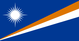
| Flag | Marshall Islands Flag |
|---|---|
| Country | Marshall Islands |
| Capital | Majuro |
| Continent | Oceania |
| Official Languages | Marshallese, English |
| Currency | US Dollar (USD) |
| Dialling Code | +692 |
Marshall Islands Flag Meaning
Flag Design
The flag of the Marshall Islands is a blue rectangle with a 19:10 aspect ratio. In the upper left corner (near the hoist), there is a white, four-pointed star with 24 rays radiating outward. Below the star, two diagonal stripes extend from the bottom left to the top right—the upper stripe is orange, and the lower one is white. The overall design conveys a dynamic upward motion, symbolizing the nation’s aspirations for the future, making it one of the most vibrant flags among Pacific island nations.
Meaning
The blue field represents the Pacific Ocean. The white star symbolizes the country and its people, with the 24 rays corresponding to the 24 inhabited electoral districts (municipalities). The four longer rays point toward the four cultural directions and also signify Christian faith and peace. The orange and white diagonal stripes represent the two main island chains: orange for the eastern Ratak (Sunrise) Chain and white for the western Ralik (Sunset) Chain. Orange also stands for courage, while white represents peace. The upward extension of the stripes symbolizes the nation’s rise.
History and Legal Status
The flag was designed by Emlain Kabua, wife of the first president, Amata Kabua. It was first raised on May 1, 1979, when the Marshall Islands Autonomous Government was established, and became the official flag after independence in 1986. Flag legislation specifies precise details regarding the number of rays, stripe widths, and color standards.
Today, the flag flies over the Majuro Capitol Building, Marshall Islands facilities near U.S. installations on Kwajalein Atoll, and fishing vessels across the Pacific. On May 1 (Flag Day) and October 21 (Independence Day), flag-raising ceremonies and traditional canoe races are held in Majuro. The flag and maritime heritage together form core symbols of Marshallese national identity.
Marshall Islands Overview
Country Details »Overview of the Marshall Islands
The Marshall Islands (officially the Republic of the Marshall Islands) are located in the eastern part of the Micronesian island group in the central Pacific. The country comprises 29 atolls and five individual islands, totaling approximately 1,156 islets and reefs. With a land area of just about 181 square kilometers, it boasts an exclusive economic zone spanning over 2 million square kilometers, making it a quintessential "small land, vast sea" nation. The population is around 42,000, with more than half concentrated on Majuro Atoll, where the capital, Majuro, is situated. The official languages are Marshallese and English.
The Marshall Islands is a presidential republic. It gained full independence on October 21, 1986, and signed the Compact of Free Association (COFA) with the United States. Under this agreement, the U.S. is responsible for defense and has access to the missile testing range on Kwajalein Atoll (Reagan Test Site). Marshall Islands citizens can live and work freely in the U.S., and the U.S. provides financial assistance as stipulated. The U.S. dollar is the official currency, and no national currency is issued.
Geography and Climate
The Marshall Islands is one of the countries with the highest density of atolls in the world. All its islands are coral atolls or low-lying sandbanks, with an average elevation of less than 2 meters and a highest point of only about 10 meters. Atolls consist of a central lagoon surrounded by a coral reef ring, resembling a string of emerald necklaces when viewed from above. Kwajalein Atoll has one of the largest lagoons in the world. Majuro Atoll comprises over 60 small islands, with several islets within its lagoon suitable for day trips.
The climate is tropical maritime, with temperatures averaging around 27°C year-round. The dry season runs from December to April, while the wet season spans May to November. Due to the extremely low elevation, rising sea levels and storm surges are critical survival issues. In recent years, king tides have repeatedly flooded roads and houses in Majuro and the outer atolls, and saltwater intrusion has contaminated the freshwater lens, making the Marshall Islands one of the most directly affected nations by global climate change.
Historical Background
The ancestors of the Marshallese arrived around 2,000 years ago by canoe, developing some of the most advanced navigation skills in the central Pacific. They used "stick charts" woven from shells and coconut midribs to record wave patterns and navigated swiftly between atolls using asymmetrical outrigger canoes (proa). This wave-piloting technique is considered an outstanding representation of Polynesian and Micronesian maritime traditions, and local efforts have long aimed to have it inscribed on the UNESCO Intangible Cultural Heritage list.
In the 16th century, Spanish navigators named the islands after British Captain Marshall. The islands later came under German colonial rule and Japanese mandate. During World War II, battles at Kwajalein and Eniwetok were pivotal in the Pacific Theater. After the war, the U.S. conducted nuclear tests here for over a decade: between 1946 and 1958, more than 60 nuclear tests were carried out at Bikini and Enewetak Atolls. The 1954 "Castle Bravo" hydrogen bomb test exceeded expectations, causing widespread radioactive fallout. Bikinians were relocated multiple times, and some Enewetak islets remain contaminated. Shortly after the 1946 Bikini tests, French designer Louis Réard named a new swimsuit "bikini," which became a global pop culture icon. After independence in 1986, the U.S. provided compensation to affected islanders through the nuclear claims tribunal under the COFA. In 2010, Bikini Atoll’s nuclear test site was inscribed on the UNESCO World Heritage List as a testament to the nuclear age.
Economy and Currency
The Marshall Islands economy heavily relies on foreign aid and external income: U.S. COFA assistance, lease and employment income related to the U.S. base on Kwajalein, fishing license fees and ship registry revenues, and remittances form the main sources. The official currency is the U.S. dollar (USD), and no national currency is issued. The tourism sector is limited, but wreck diving at Bikini Atoll—including the sunken USS Saratoga aircraft carrier—is highly regarded globally. Only a few liveaboard trips are offered each year, requiring early booking. Copra (dried coconut) and handmade crafts are important sidelines for outer island residents, with traditional pandanus weaving from Ailinglaplap and other atolls enjoying a strong reputation in the Pacific.
Culture and Society
Marshallese society is built on extended family and clan structures, with deep respect for chiefs and elders. Land and lagoon usage rights are inherited within families. Handicrafts are highly developed: coconut leaf hats, mats, fans, and shell jewelry are both daily necessities and key export items. Traditional "Jaki-ed" weaving has seen a revival in recent years, becoming a symbol of cultural identity. The diet centers around coconuts, breadfruit, taro, and seafood. Common home-cooked dishes include fish cooked in coconut milk and roasted breadfruit.
Christianity, predominantly Protestant denominations, is the main religion. Churches serve as community hubs, and Sunday is an important day for family and worship. Marshallese people are warm and hospitable, often welcoming visitors with traditional flower garlands. For many families, working in the U.S. and sending remittances is a normal part of life. Life on the islands is slow-paced, with strong community ties.
Tourism Overview
The Marshall Islands appeal to in-depth travelers interested in the ocean, history, and anthropology. Majuro Atoll offers lagoon hopping, day trips to Laura Beach, and visits to the Alele Museum’s collections of stick charts and weaving. Arno Atoll is known for its white-sand beaches and traditional villages. Wreck diving at Bikini Atoll—a world heritage-level experience—is the ultimate activity, operated exclusively by specialized liveaboard companies. Kwajalein Atoll is largely restricted due to military use, with limited access to places like Ebeye for approved visitors. Due to flight frequency and accommodation limitations, a 4–7 day trip centered on Majuro is the most practical, with outer atoll itineraries requiring months of advance planning and flexibility.
Marshall Islands Travel Guide
All Guides »Marshall Islands Travel Quick Guide: Visa Options, Seasons, Budget & Nuclear Heritage Etiquette
Your Marshall Islands trip will focus on Majuro and outer atoll boat transfers: ...
Classic 7-Day Marshall Islands Itinerary: Majuro Atoll — Arno — Outer Atolls on a Liveaboard 7 Days
Base yourself in Majuro for seven days to explore lagoon island-hopping, the Ale...
4-Day Marshall Islands Short Trip: Slow Travel Around Majuro Atoll, Lagoon, and Beaches 4 Days
With just 4 days, focus on Majuro: explore museums, island-hop in the lagoon, an...
Must-visit attractions in the Marshall Islands: Bikini Atoll, lagoon islands, and wave pattern collections
From the UNESCO World Heritage nuclear test site at Bikini Atoll to picnic islan...
Marshall Islands Food Guide: Coconut-Braised Fish, Breadfruit, and Fresh Tuna Sashimi
Marshall Islands cuisine is all about seafood: tuna, reef fish, and breadfruit t...
Marshall Islands Transportation Guide: A Complete Overview of Island Flights, Taxis, and Outer Atoll Boats
The Marshall Islands travel trio: island flights running about twice a week, met...