Bolivia Flag
The proportions, colors, and history of Bolivia's flag - a banner that tells Bolivia's own story.
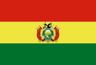
| Flag | Bolivia Flag |
|---|---|
| Country | Bolivia |
| Capital | Sucre (government seat in La Paz) |
| Continent | South America |
| Official Languages | Spanish |
| Currency | Boliviano (BOB) |
| Dialling Code | +591 |
Bolivia Flag Meaning
Flag Design
Bolivia’s tricolor flag features horizontal equal bands of red (top), yellow (middle), and green (bottom) in a 3:2 ratio. Two versions exist: the civil flag (plain tricolor) and the state/government flag (with the national coat of arms centered), used by officials and in ceremonies. The coat of arms depicts Potosí’s Cerro Rico, llamas, wheat sheaves, rifles, and laurel branches, flanked by national flags and olive wreaths, topped by a condor—a symbol of resources, independence, and freedom.
Symbolism
Traditionally, red represents blood shed for independence, yellow signifies mineral wealth, and green stands for fertile land and agriculture. The 2009 constitution also recognized the Wiphala (an indigenous rainbow flag) as a national symbol, often displayed alongside the tricolor to reflect Bolivia’s multicultural identity.
History and Legal Status
The current tricolor was adopted in 1851, replacing earlier variants, and is celebrated annually on Flag Day (August 17). The constitution protects the flag, coat of arms, and anthem, along with the Wiphala.
Bolivia Overview
Country Details »Bolivia Overview
Bolivia (officially the Plurinational State of Bolivia) is a landlocked country in central South America, bordered by Brazil to the north and northeast, Peru to the northwest, Chile and Argentina to the south, and Paraguay to the southeast, covering about 1.099 million km². Its constitutional capital is Sucre, while La Paz (the seat of government, parliament, and main administrative bodies) is often considered the de facto capital. At 3,600–4,000 m altitude, it’s one of the world’s highest capital cities. The country has nine departments, with Spanish as the official language alongside over 30 indigenous languages like Quechua, Aymara, and Guarani.
Bolivia has one of South America’s highest proportions of indigenous peoples, with Aymara and Quechua communities maintaining distinct languages, traditional dress, and spiritual practices in the highlands—a blend of pre-Columbian heritage and colonial history.
Geography and Climate
Bolivia’s terrain divides into three regions: the Andean Altiplano (3,600–4,000 m), home to Lake Titicaca, La Paz, and Oruro, with 6,542 m Sajama Volcano as the highest peak; the temperate Eastern Cordillera valleys (Sucre, Cochabamba); and the vast Amazonian lowlands (east/northeast), where Santa Cruz serves as the economic hub.
Climate varies sharply by altitude: the highlands are cold year-round with extreme diurnal temperature swings—dry season (May–October) brings sunny days and freezing nights, while the rainy season (December–March) features precipitation and occasional snow. Valleys enjoy spring-like conditions, while eastern lowlands are tropical, hot, and humid. Pack accordingly for elevation changes.
Historical Background
The Andean region, home to the Inca Empire, includes Tiwanaku—a pre-Inca civilization near Lake Titicaca. Spanish colonizers arrived in the 16th century, exploiting Potosí’s silver mines to fuel the colonial economy. Potosí briefly ranked among the wealthiest cities globally, leaving a legacy of colonial architecture and mining hardships.
Liberation began with La Paz’s uprising in 1809, leading to independence in 1825 under Simón Bolívar’s name. Territorial losses (e.g., the 1884 secession of Pacific-coast Antofagasta) left Bolivia landlocked. 20th-century coups gave way to democratic reforms, culminating in the 2009 constitution renaming the country the “Plurinational State of Bolivia” to emphasize indigenous rights and resource sovereignty.
Economy and Currency
Key sectors include mining (tin, silver, zinc, lithium), natural gas, and agriculture. The Uyuni Salt Flats region holds world-class lithium reserves. Natural gas is a major export, alongside growing quinoa (an Andean staple) and soybean shipments.
The official currency is the Boliviano (BOB, symbol Bs.), issued by the Central Bank of Bolivia. One boliviano equals 100 centavos. The currency maintains relatively stable exchange rates with the U.S. dollar, earning a reputation for reliability in Latin America.
Culture and Society
Indigenous traditions deeply influence daily life: Aymara women’s bowler hats and layered skirts, Andean textiles, syncretic festivals (like Oruro’s Carnival), and coca leaf/Pachamama rituals are iconic. Oruro’s Carnival is a UNESCO Intangible Cultural Heritage.
Highland cuisine features potatoes, quinoa, and corn—try sajta (stew), salteñas (savory pastries), empanadas, and api (corn drink). La Paz’s Witches’ Market offers herbs, talismans, and handicrafts tied to folk beliefs.
Tourism Highlights
Top draws include the Uyuni Salt Flats (world’s largest), whose “mirror” effect appears after rains (December–March), and its dry-season salt formations and cacti islands. La Paz’s Mi Teleférico cable car system connects valley neighborhoods, while its colonial center, Murillo Square, and Witches’ Market captivate visitors. The Sun Island (Isla del Sol) on Lake Titicaca—linked to Inca origins—is accessible from Copacabana. Sucre’s whitewashed colonial district and Potosí’s silver-mining heritage are UNESCO-listed.
Heed altitude precautions: over 3,500 m elevation in Uyuni and La Paz can trigger altitude sickness—rest upon arrival. For rugged routes (e.g., 3-day salt flat tours), book reputable operators and pack warm layers.
Bolivia Travel Guide
All Guides »Bolivia Travel Snapshot: Visa, Seasons, Budget & Altitude Essentials
Before traveling to Bolivia, clarify these key points: visa requirements, travel...
Classic 8-Day Bolivia Itinerary: La Paz — Uyuni — Lake Titicaca 8 Days
This is Bolivia’s most classic combination route, covering the high-altitude cap...
Bolivia 4-Day Short Trip: Highlights of La Paz and Uyuni 4 days
See the Mirror of the Sky even with limited time: Use La Paz as your gateway and...
Must-Visit Attractions in Bolivia: Salt Flats, High Plateaus, and Colonial Cities
From the world’s largest salt flat to the sacred Inca lake, here’s a regional gu...
Bolivia Food Guide: Highland Flavors and Street Snacks
Highland potatoes, quinoa, and savory pastries—Bolivian cuisine is simple yet la...
Bolivia Transportation Guide: Cable Cars, Overnight Buses & Salt Flats
Transportation in high-altitude countries has its own unique aspects. In Bolivia...