Mauritania Flag
The proportions, colors, and history of Mauritania's flag - a banner that tells Mauritania's own story.
| Flag | Mauritania Flag |
|---|---|
| Country | Mauritania |
| Capital | Nouakchott |
| Continent | Africa |
| Official Languages | Arabic |
| Currency | Mauritanian ouguiya (MRU) |
| Dialling Code | +222 |
Mauritania Flag Meaning
Flag Design
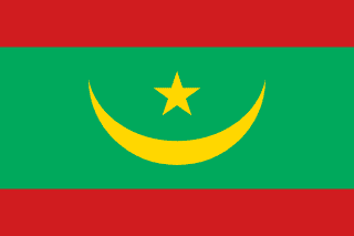
The Mauritanian flag is rectangular with a 2:3 aspect ratio. The field is green, featuring a golden crescent moon with its opening facing upward, and a five-pointed star nestled within the horns of the crescent. Following a 2017 constitutional referendum, a red stripe was added to the top and bottom of the flag, creating the current design of a green background with golden emblems and red borders. The layout is symmetrical, dignified, and highly recognizable.
Meaning
Green represents Islam and the aspiration for peace, as well as the vitality of oases in the Sahara. The golden crescent and star are universal symbols of the Islamic world and also reflect the golden hue of the desert sands. The red stripes added in 2017 officially commemorate the martyrs who sacrificed for the country’s independence and freedom, symbolizing the struggle and unity of the people. Together, the red, green, and gold colors reflect Mauritania’s identity as an Arab-Islamic nation in the Sahel region.
History and Legal Status
Mauritania adopted the green flag with a golden crescent and star upon gaining independence in 1960, and it remained in use for over half a century. In 2017, a constitutional amendment referendum not only adjusted certain national institutions but also introduced red stripes to the flag and modified other national symbols such as the national anthem to strengthen national cohesion. The new flag features standardized colors and proportions officially released by the government, and is widely used by government agencies, the military, embassies and consulates abroad, and at sporting events. It is a key component of the national image. The green and gold colors are also considered to reflect the coexistence of desert and oases in the country’s landscape, while the red stripes add solemnity to the overall design, making it one of the most recognizable national symbols of modern Mauritania.
Mauritania Overview
Country Details »Mauritania Overview
Mauritania (officially the Islamic Republic of Mauritania) is located in northwestern Africa, bordering the Atlantic Ocean to the west, Western Sahara and Algeria to the north, Mali to the east and southeast, and Senegal to the south along the Senegal River. Covering an area of approximately 1.03 million square kilometers, it ranks among the larger countries in Africa, though most of its territory is covered by the Sahara Desert and the Sahel arid zone, leaving limited land suitable for habitation and agriculture. The capital, Nouakchott, is situated on the Atlantic coast and is the country’s largest city as well as its political and economic center, with its metropolitan population accounting for about a quarter of the national total.
The official language is Arabic, while French is widely used in administration and education. Hassaniya, a variety of the Moorish language, is commonly spoken in daily life. Islam is the state religion, and the country operates as a presidential republic, with its parliament and judicial system undergoing continuous adjustments in recent years. Geographically, Mauritania lies in the transitional zone between North Africa’s Maghreb region and sub-Saharan Africa, where Arab-Berber culture intersects with Black African culture, resulting in a unique and complex social structure.
Geography and Climate
The country’s terrain can be roughly divided into four zones: the western coastal area consists of narrow sand dune plains and lagoon wetlands; the central region features vast rocky deserts and sand dunes; the northeastern Adrar Plateau is known for its sandstone plateaus, canyons, and oases; and the southern areas along the Senegal River comprise Sahelian grasslands. Most hills in the country rise just a few hundred meters and have gentle undulations. What truly shapes the landscape here is wind and sand—shifting dunes continuously erode the edges of ancient cities, making this region a natural classroom for observing desertification.
The climate is tropical desert, characterized by year-round heat and dryness in the north, with significant day-night temperature variations. The southern Sahelian zone experiences a brief rainy season from July to September. The coastal areas are influenced by the Canary Current, making summers in Nouakchott and Nouadhibou relatively cool and foggy, though humidity remains high. Inland summer temperatures often exceed 40°C, and the harmattan winds bring sandstorms and sudden drops in visibility, so travelers should allow flexibility in their schedules.
Historical Background
In the 11th century, the Sanhaja Berbers, originating from what is now Mauritania, established the Almoravid dynasty, which at its peak extended as far as the Iberian Peninsula and North Africa, profoundly influencing the religious and trade routes of West Africa and the Mediterranean. Later, the trans-Saharan trade in gold and salt brought centuries of prosperity to oasis waystations such as Chinguetti, Ouadane, and Oualata, where caravans, scholars, and pilgrims passed through, leaving behind a wealth of Arabic manuscripts and private libraries.
From the 15th century onward, Portuguese, Dutch, and French traders arrived along the coast to engage in trade in gum arabic and fish. In 1904, Mauritania became a French colony and gained full independence in 1960. In 1976, tensions arose with neighboring countries over the Western Sahara issue, followed by several political adjustments. A multi-party system was implemented in 1991, and in 2017, a national referendum revised the national flag and certain institutional elements. The country has long sought balance in combating desertification, reducing poverty, and promoting ethnic integration.
Economy and Currency
Mining and fishing are the cornerstones of Mauritania’s economy. Iron ore from the Zouérat region is transported via a dedicated railway to the port of Nouadhibou for export. This railway operates one of the longest trains in the world, with heavy-laden consists stretching nearly 2.5 kilometers, offering a spectacular sight as they traverse the desert. The coastal waters are rich in fishery resources, making Mauritania an important exporter of fish and fishmeal in Africa. Gold, copper, and recently operational offshore natural gas also contribute to national revenues. Agriculture and livestock farming are constrained by drought, and much of the food supply is imported.
The national currency is the Mauritanian ouguiya (currency code MRU, symbol UM). In 2018, the country underwent a currency reform, replacing 10 old ouguiyas with 1 new ouguiya and issuing a new series of banknotes. The local currency is not typically exchanged directly for foreign currencies other than the euro or U.S. dollar. Travelers usually carry euro or U.S. dollar cash and exchange it for ouguiyas upon arrival.
Culture and Society
Mauritanian society comprises multiple ethnic groups: the dominant White Moors (Beydane), who trace their identity to Arab-Berber heritage and speak Hassaniya; the Haratin, historically in a subordinate position; and various Black African groups such as the Fulani, Soninke, and Wolof. Ethnic and class differences have long existed, and the government has recently legislated efforts to promote social integration and combat vestiges of slavery.
A defining feature of daily life is the Moorish tradition of serving "three cups of tea": one bitter, one sweet, and one light. Hosts serve tea to guests as part of an important social ritual involving conversation over tea. The wide headscarf (melehfa or cheche) serves both to shield against sun and sand and as a symbol of identity and custom. Camels, tents, and the music of the green lute (tidinit) form the foundation of nomadic culture, while women’s silver jewelry and handmade textiles continue ancient aesthetic traditions.
Tourism Overview
Mauritania is a desert destination tailored for intrepid travelers. The UNESCO World Heritage Site “Ancient Ksour of Ouadane, Chinguetti, Tichitt and Oualata” preserves the caravan station civilization of the Sahara trading era. Among its highlights are Chinguetti’s stone old town and ancient libraries, and Oualata’s painted houses. Sand dunes encroaching on these historic urban areas have earned them the nickname “cities chased by the desert,” offering both stunning views and a palpable sense of urgency about time. Other key experiences include the Adrar Plateau’s canyons and oases, the Richat Structure (known as the “Eye of the Sahara”), the migratory bird-filled lagoon wetlands of Banc d’Arguin National Park, and the iron ore railways crossing the dunes.
It should be noted that the eastern and southeastern border regions of Mauritania adjoining Mali (such as areas near Néma and Timbedra) face ongoing risks of terrorism and kidnapping, and many governments advise against travel there. Some areas near northwestern Mauritania close to Western Sahara still have landmine hazards, so self-driving across such regions requires sticking to confirmed routes. Security in coastal cities and main tourist sites is generally manageable, but travelers should remain vigilant and avoid nighttime travel over long distances. Before departure, check the latest travel advisories from your government’s foreign office, choose licensed local tour operators, and purchase travel insurance covering emergency rescue and evacuation.
Mauritania Travel Guide
All Guides »Mauritania Travel Essentials: e-Visa, Cool Season, Budget & Desert Etiquette
How to choose between a visa and visa on arrival, which months are best for dese...
Mauritania 7-Day Classic Route: Ancient Cities of Adrar and Migratory Bird Coast 7 days
Journey from the Atlantic coast into the Sahara outposts, connecting the UNESCO ...
Mauritania 4-Day Itinerary: Capital and Ancient Cities of Adrar 4 days
A reliable option for limited time: experience the capital city along with the A...
Essential Attractions in Mauritania: Ancient Cities, Desert Wonders, and Migratory Bird Coastlines
Organized by category—World Heritage ancient cities, desert natural wonders, coa...
Mauritania Food Guide: Grilled Lamb, Fish Couscous, and Three-Course Tea
A blend of Moorish traditions and Sahel flavors, from grilled lamb and camel mea...
Mauritania Transport Guide: Airports, 4x4 Car Hire, and Iron Ore Trains
Learn how to get to and from Nouakchott Airport, use domestic small planes, and ...