Suriname Flag
The proportions, colors, and history of Suriname's flag - a banner that tells Suriname's own story.
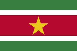
| Flag | Suriname Flag |
|---|---|
| Country | Suriname |
| Capital | Paramaribo |
| Continent | South America |
| Official Languages | Dutch |
| Currency | Surinamese Dollar (SRD) |
| Dialling Code | +597 |
Suriname Flag Meaning
Flag Design
The flag of Suriname was officially adopted on November 25, 1975, the day of independence. It was selected through a public competition won by graphic designer Jack Pinas. The flag is rectangular with a 2:3 aspect ratio, consisting of five horizontal stripes from top to bottom: green, white, red, white, and green. Their width proportions are 2:1:4:1:2, with a prominent yellow five-pointed star centered within the red stripe. The yellow star has a diameter of about one-third the height of the flag and serves as its visual focal point.
Meaning
Green represents the fertile land and abundant natural resources of Suriname, as well as the people’s hopes for the nation’s future. White symbolizes freedom, justice, and peace. Red stands for progress, enthusiasm, and the sacrifices made for independence. The central yellow star signifies the unity of all ethnic groups and the bright prospects of the country. Together, the five colors reflect the diverse society composed of Indo-Surinamese, Maroons, Creoles, Javanese, and Indigenous peoples.
History and Legal Status
During the colonial period, Suriname flew the Dutch flag. In 1959, a flag featuring a white background with an oval connecting five colored stars (each representing a major ethnic group) was used but was redesigned as independence approached. In 1975, then-Prime Minister Henck Arron launched a competition for flag and coat of arms designs. Jack Pinas’s design was chosen from hundreds of entries, with the black star in the original version changed to yellow in the final design. In 1986, the Surinamese government enacted a flag law requiring the flag to be displayed at government buildings, courts, military bases, and schools. November 25, Independence Day, is also commonly observed as Flag Day.
Suriname Overview
Country Details »About Suriname
Suriname (officially the Republic of Suriname, Republiek Suriname) is located in northeastern South America, bordered by Guyana to the west, French Guiana to the east, Brazil to the south, and the Atlantic Ocean to the north. It covers an area of about 164,000 square kilometers, making it the smallest sovereign country on the continent. The nation has a population of around 620,000, nearly half of whom live in the capital, Paramaribo. It is the only country in South America where Dutch is the official language. Sranan Tongo (a Creole language) is commonly spoken in daily life, along with English, Sarnami (Hindustani), Javanese, and various Maroon and Indigenous languages.
Over 90% of Suriname’s territory is covered by Amazon rainforest, giving it one of the highest forest coverage rates in the world and earning it a well-deserved reputation as a green nation. Its society is composed of Indo-Surinamese, Maroons, Creoles, Javanese, Indigenous peoples, Chinese, Dutch descendants, and others, making it one of the most ethnically diverse countries in South America.
Geography and Climate
Suriname’s terrain slopes from south to north and can be divided into three main zones: the northern coastal lowland plains (where most of the population and farmland are concentrated), the central tropical rainforest and hilly regions, and the southern Guiana Highlands. Juliana Top (approximately 1,280 meters) in the south is the country’s highest point. Major rivers include the Courantyne, Maroni, Suriname, and Saramacca, all flowing from south to north into the Atlantic. The Central Suriname Nature Reserve in the central part of the country is a UNESCO World Heritage Site, preserving vast areas of pristine rainforest.
The climate is tropical rainforest, characterized by high temperatures and humidity year-round, with average annual temperatures ranging from 23–31°C and abundant rainfall. There are roughly two main rainy seasons (April to August and November to February of the following year) and two relatively drier periods. The northern coastal region is moderated by the northeast trade winds, while the inland rainforest is hot, humid, and mosquito-prone—mosquito repellent is essential.
Historical Background
Suriname was originally home to Indigenous peoples such as the Arawak and Carib. In the mid-17th century, the British established a colony here. In 1667, the Netherlands and Britain signed the Treaty of Breda, with the Netherlands exchanging New Amsterdam (now New York) for Suriname. This marked the beginning of over 300 years of Dutch rule, with a brief interlude of British control. The colonial economy relied on sugarcane, coffee, and cotton plantations worked by enslaved Africans brought from West Africa. Slavery was abolished in 1863, but full freedom did not come until 1873. Afterward, the Dutch brought indentured laborers from British India, Java, and China, forming the diverse population seen today.
In 1954, Suriname became an autonomous constituent country within the Kingdom of the Netherlands. It gained full independence on November 25, 1975. Post-independence politics were often unstable, with a military coup in 1980 and internal conflict in the late 1980s impacting social and economic development. The country gradually returned to democratic elections, with a coalition government led by the Progressive Reform Party taking office in 2020. There is a minor border dispute with Guyana over the Courantyne River area, and past disagreements also existed regarding the Maroni River border with French Guiana.
Economy and Currency
Suriname’s economy has long depended on the export of bauxite (bauxite ore, alumina, and aluminum ingots), gold, oil, timber, rice, and bananas, with the bauxite industry historically serving as the backbone of the national economy. In recent years, offshore oil and gas exploration has shown promise as a key driver of future growth. The official currency is the Surinamese Dollar (SRD, symbol $), which replaced the Surinamese Guilder on January 1, 2004. The official exchange rate was initially pegged to the US Dollar but transitioned to a free-floating system in 2021, resulting in significant fluctuations and noticeable inflation. US Dollars and Euros are widely accepted in hotels, tour packages, and high-value purchases.
Culture and Society
Suriname is one of the most ethnically and religiously diverse countries in the Western Hemisphere. Indo-Surinamese make up about a quarter to a third of the population, Maroons (descendants of escaped slaves, mainly living along inland rivers) and Creoles together account for roughly 30%, Javanese around 15%, and there are also Chinese, Indigenous peoples, Portuguese Jews, and Dutch descendants. Hinduism, Islam, Christianity, and indigenous beliefs coexist. In Paramaribo, mosques and synagogues have long stood side by side, symbolizing peaceful coexistence. The cuisine blends Indian, Javanese, Creole, and Dutch flavors, with dishes like roti, bakkeljauw (salted cod), saoto soup, pom, and nasi being national favorites. Among official holidays, Independence Day on November 25 is celebrated alongside various ethnic festivals.
Tourism Overview
Tourism in Suriname focuses on ecotourism and cultural heritage: the wooden colonial old town of Paramaribo was inscribed as a UNESCO World Heritage Site in 2002, featuring Dutch-style wooden houses, the Saint Peter and Paul Wooden Cathedral, Fort Zeelandia, and Independence Square. The nearby Jodensavanne (Jews’ Savannah), a 17th-century settlement of Sephardic Jews, was added to the World Heritage list in 2023. The inland Central Suriname Nature Reserve, Brownsberg Nature Park, and Maroon and Indigenous villages are ideal for rainforest hikes, riverboat cruises, and birdwatching. Galibi Nature Reserve is a prime spot to see leatherback and green turtles laying eggs from February to August. Coffee and rum enthusiasts can visit former plantations along the Commewijne River. Overall, Suriname’s infrastructure is relatively basic, with inland travel mostly relying on chartered boats, cars, and small planes. Some areas of Paramaribo have safety concerns, and it is advisable to arrange remote trips through local tour operators.
Suriname Travel Guide
All Guides »Suriname Travel Snapshot: Visa-Free Entry, Seasons, Budget, and Multicultural Etiquette
Visitors to Suriname can enter visa-free for up to 30 days, but must prepay the ...
Classic 7-Day Suriname Itinerary: Paramaribo – Rainforest Interior – Turtle Beach 7 days
Journey from a wooden colonial old town into pristine rainforests, then to turtl...
Suriname 4-Day Short Trip: In-Depth Exploration of Paramaribo and Its Suburbs 4 Days
Based in Paramaribo, this itinerary covers the UNESCO-listed historic old town, ...
Must-visit attractions in Suriname: UNESCO-listed historic towns and pristine rainforests
Organized by city and nature zones, this list highlights Suriname’s top sights, ...
Suriname Food Guide: Roti, Bakkeljauw, and Javanese Flavors
With influences from India, Java, Creole, and the Netherlands, Suriname is one o...
Suriname Travel Guide: Airport Transfers, Local Transport, and Inland Boat Charters
How to arrange transport within Paramaribo, transfers to and from the airport, a...