Explorers Power the Geek Mountain Marathon for the Winter Olympics
TOREAD Geek Mountain Marathon
“Bravely transform, let’s run together!”
Where on earth is that world full of flowers?
If it truly exists, I will surely go there.
I want to stand atop the highest peak there,
never mind if it’s a sheer cliff.
Run forward, facing cold stares and ridicule.
The vastness of life — how can you feel it without going through trials?
Keep running. With the pride of a child.
The sparkle of life — how can you see it without persevering to the end?
Rather than dragging out a pointless existence, burn with passion instead.
— “Home” (The Song of the Dream-chasing Heart)
 Here is that world full of flowers;
here the average summer temperature is just18.1°C, like a natural central air conditioner;
here the forests are dense, with negative oxygen ion concentration in the air over10times higher than in urban areas;
here the environment is beautiful, with forests, flower clusters, grasslands, clouds… like a fairyland;
here the culture is rich — the Ming Great Wall ruins stretch from north to south, like a giant dragon traversing the lofty mountains;
this is the Dolomiti Mountain Sports Resort.
Beijing Toread Outdoor Products Co., Ltd.
II. Supporting Organizations
National Stadium (Bird’s Nest)
Chinese National Geography Magazine/Chinese National Geography New Media
Green Field Rescue Team
Neusoft Saik
Beijing Yipao Information Technology Co., Ltd.
Dongle Sports Network
Yiji Fitness Training Camp
Our Sports Development (Beijing) Co., Ltd.
III. Organizer
Geek Adventure (Beijing) Outdoor Operation & Management Co., Ltd.
Dolomiti Mountain Sports Resort
IV. Sponsors
Main Sponsor of the Event:
Toread
Other Partner Sponsors:
Wild Walker Energy Gels;SPYEyewear: Himalaya; Nitecore
V. Media Partners
Sina Outdoor, Sina Running, Sohu Outdoor, NetEase Outdoor, Youku Sports Channel,GEO(Geo), China National Geography, Yipao Network, Dongle Network, Tencent Travel, Men’s Health, Runner’s World, New Sports Magazine, China Sports Daily, Men’s Health, Healthy Lifestyle, Health & Friends, Leader, Mountain Wilderness,SIZEOutdoor Enthusiasts, Outdoor Equipment, Outdoor Exploration, The Beijing News, National Geographic China,8264, Green Field, China Outdoor Network, Little Sheep Army, Peak Journey.
VI. Supporting Running Clubs
Geek Runners Club, Guangzhou Running Club, Kingsmith Running Club, Zhengtu Charity Running Club, Yi Ji Fitness Training Camp, Temple of Heaven Joy Run, Iron Wings Skyrunning Club, Yun Speed, Olympic Forest Park Running Academy, Yun Liang Running, Chaoyang Park Running Club, Green Run Sunshine Running Club, Green Run Salomon Running Club, Beijing Off-road, Circus, White Collar Run Alliance,110Running Club, White-Collar Run Club, Easy Run Help, Fragrant Hill Running Club, Tongzhou Long-Distance Running Camp, Haoliang Running Club
VII. Event Date and Location
Date:2015Year8Month2Day
Location: Dolomiti Mountain Sports Resort, Chongli County, Zhangjiakou City, Hebei Province
VIII. Competition Events
1. Men’s Division: Full Marathon42km, Half Marathon21km, Fun Run10km;
2. Women’s Division: Full Marathon42km, Half Marathon21km experience run10km;
Nine. Registration time and quotas
1.Registration time:2015Year7Month7to 2015Year7Month20Date(First-come, first-served until full)
2.Quota limits: Full course group42km:150people
Half course group21km:150people
Experience run10km:200people
Ten. Race-day schedule
2015Year8Month2(Sunday):
Pre-race schedule:
06:00-07:00 On-site collection of race gear
06:00-07:40 Participants' clothing storage
06:30-07:40 Participants' check-in and entry into designated waiting areas
07:30-07:44 Professional warm-up coaches will lead all participants in a warm-up session
07:45-07:59 Introduction of attending guests, speeches by leaders, and the starting ceremony of the race
08:00Full course42kmGroup, half course21kmGroup, and experience run10kmGroup start their races with the firing of the starting gun
Race schedule:
42KMStarting time:8:00minutes The race will close at10hours
The race will end at18:00minutes
21KMStarting time:8:00minutes The race will close at06hours
The race will end at14:00minutes
10KMStarting time:8:00minutes The race will close at03hours
The race will end at11:00minutes
Award ceremony:
10KMGroup award ceremony:10:00Begins
21KMGroup award ceremony:12:00Begins
42KMGroup award ceremony:14:00Begins
XI. Race Information and Services
1Setup of Start and Finish Points
Both the start and finish points are located within the Dolomiti Mountain Sports Resort, forming a closed-loop route.
2Route Description
Route Features: Primarily unpaved surfaces such as dirt roads, mountain trails, and grasslands, where42kilometers of the non-paved course account for65%or more;21kilometer category features non-paved sections covering84%or more;10kilometer category features non-paved sections making up76%or more.
3Race Course and Elevation Map
10Kilometer Detailed Description of the Race Route
Start Point: Chongli Dolomiti Mountain Sports Resort
Finish Point: Chongli Dolomiti Mountain Sports Resort
Route Description:
10kmElevation Map for the [Category]
1.
Start Point —CP1After departure, follow the paved road inside the resort downhill to the1kmErdaogou intersection, where you’ll begin ascending into the mountains along Erdaogou. The first half of the route follows visible vehicle tracks, and after reaching the Erdaogou Campsite, go straight through the camp and continue following the trail markers. You’ll traverse steep grassy slopes before reaching the main road, where theCP1checkpoint will be located at the roadside junction.
2.
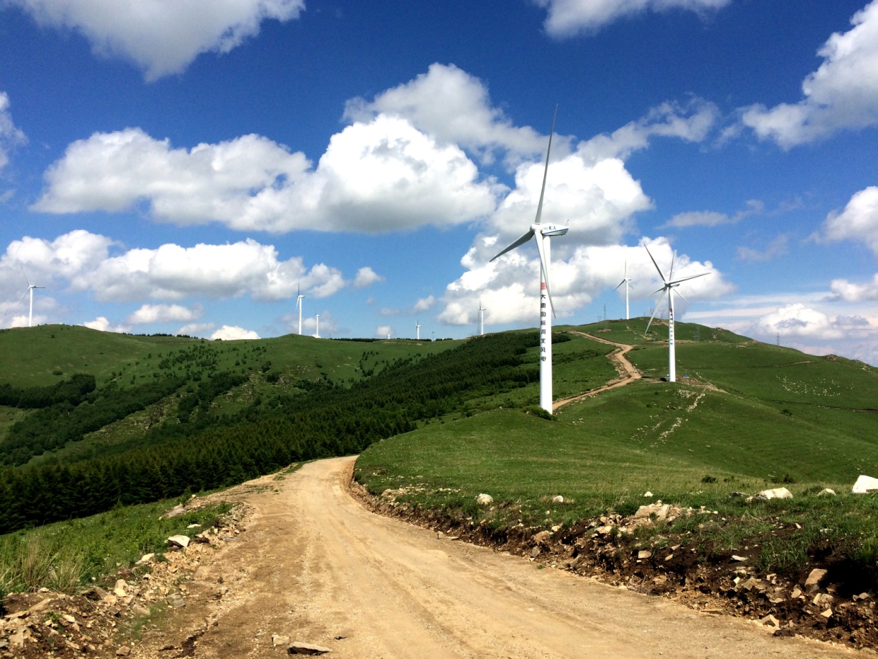
CP1?―CP2Then, after checking in atCP1, continue ascending along the roadside for approximately600meters until you reach the entrance of the Magpie Ridge Scenic Area, where the first aid station,SP1, is set up. After replenishing, you’ll enter the scenic area. Upon passing through the scenic gate, follow the right-side stone path into the woods. Along the roughly500-meter forest trail, you’ll be accompanied by dense pine trees, offering a cool and refreshing atmosphere. After exiting the forest, turn right into the Magpie Ridge Camping Area and proceed along the stone path, where you can enjoy panoramic views of the majestic Chongli mountain ranges. After leaving the camping area, return to the main road of Magpie Ridge, also known as the "Wind Road" (an unpaved trail). As you continue along the Wind Road, you’ll be accompanied on both sides by hundreds of giant wind turbines standing about70meters tall. Shortly after passing Magpie Nest, you’ll reachCP2andSP2, where participants must check in and replenish supplies.
3.
CP2— Finish Point:10kmFor the [Category] participants, after checking in and refueling atCP2/SP2, turn left to begin the final downhill section. Due to the steep terrain and dense woods and grasslands, proceed downhill carefully while following the trail markers to avoid getting lost or twisting an ankle. Once you pass through the denser forested area, the paths created by off-road vehicles will become clearer. When you catch a distant view of the Dolomiti Hotel, the finish line is just around the corner — sprint toward it. The finish line is located at the same spot as the start point, so don’t run the wrong way.
21Kilometers Detailed description of the race route
Start point: Chongli Dolomiti Mountain Sports Resort
End point: Chongli Dolomiti Mountain Sports Resort
Route Description:
1.
Start—CP1After departure, follow the paved road inside the resort downhill until you reach1kmthe intersection at Erdaogou, where you’ll begin ascending into the mountains. The first part of the climb follows vehicle tracks. Upon reaching the Erdaogou campsite, go straight through the camp and continue following the trail markers. You will traverse a steep grassy slope before emerging onto a road.CP1The checkpoint will be located at the roadside junction.
2.
CP1?―CP2AfterCP1checking in, continue uphill along the roadside for about600meters to reach the entrance of the Magpie Ridge Scenic Area, where the first aid station is set up.SP1After replenishing supplies, participants will enter the scenic area. After passing through the main gate, follow the stone path on the right to walk through the woods. Along the approximately500-meter forest trail, you’ll be surrounded by dense pine trees, offering a refreshing experience. After exiting the woods, turn right to enter the Magpie Ridge Camping Area. Continue along the stone path where you can enjoy views of the majestic Chongli mountain ranges. Once you exit the camping area, return to the main road of Magpie Ridge, also known as the Wind Turbine Road (a dirt road). As you proceed along this road, you’ll be accompanied by hundreds of massive wind turbines, each around70meters tall. Shortly after passing Magpie Nest, you’ll reachCP2andSP2, where you must check in and replenish supplies.
3.
CP2―CP6,21kmFor the group, afterCP2/SP2checking in and refueling, turn right and continue along the Wind Turbine Road until you reach the furthest platform at the end of the road. Then turn right and ascend along the vehicle track dirt path. After passing through a gap in the Great Wall, you’ll arrive atCP6the checkpoint andSP6the aid station.
1.
CP6―CP7AfterCP6/SP6checking in and replenishing supplies, follow the Ming Dynasty’s ruined Great Wall for about400meters. Then, follow the trail markers and guidance from volunteers to cross the Great Wall again, continuing along the mountain ridge path. This section features dense grass, so proceed with caution to avoid twisting your ankle. After advancing roughly1kilometers, descend the mountain according to the trail markers. The slope is quite steep, so be careful to avoid injury. After descending, follow the field path until you reachCP7the checkpoint andSP7the aid station.
2.
CP7— End point. AfterCP7/SP7checking in and replenishing supplies, follow the village road through Shuiquanzi Village, then continue along the village road. Upon reaching the entrance of Yaoziwan Village, do not enter the village. Instead, turn left onto the village road beside the village until you reach the mountain entrance, where you’ll enter a dirt road. Run along the gravel mountain path for about1After running more than 210 kilometers, you’ll reach the highway, and the entrance to the Dolomiti Mountain Sports Resort is not far away. But the final sprint is an uphill climb — if you still have the energy, run for the finish line!
42Kilometer details about the race route
Start point: Chongli Dolomiti Mountain Sports Resort
End point: Chongli Dolomiti Mountain Sports Resort
Route description:
1.
Start point—CP1After departure, follow the resort’s asphalt road downhill until you reach1kmthe intersection at Erdao Valley, where you’ll begin heading into the mountains, climbing all the way up through Erdao Valley. The first half of the course follows visible vehicle tracks. Upon reaching the Erdao Valley campsite, go straight through the camp and continue following the course markers. Runners will then pass through steep grassy slopes before reaching the highway,CP1where the checkpoint will be set up by the intersecting road.
2. CP1―CP2AfterCP1checking in, continue uphill along the side of the highway for approximately600meters until you reach the entrance to the Magpie Ridge Scenic Area, where the first aid station is located.SP1After refueling, runners will enter the Magpie Ridge Scenic Area. After passing through the scenic area gate, they’ll take the stone path on the right and enter the woods. The approximately500-meter-long forest trail is lined with dense pine trees, creating a cool and pleasant atmosphere. Exiting the woods, runners will turn right into the Magpie Ridge Camping Area and follow the stone path, where they can enjoy a distant view of the majestic Chongli mountain ranges. After leaving the camping area, runners will return to the main road of Magpie Ridge, also known as the Wind Power Road (dirt road). Along this road, runners will be accompanied by hundreds of giant wind turbines, each about70meters tall.