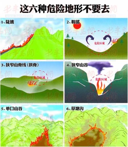
Six dangerous terrains to avoid
Every spring, the weather tends to be dry, and more people hike and explore the mountains, increasing the risk of wildfires. At 15:00 on March 20, the city meteorological bureau issued a forest fire risk level of 4 (out of a maximum of 5), indicating a severe mountain fire prevention situation. So what should we do in the event of a wildfire? How can we conduct scientific firefighting while ensuring our own safety? On March 20, staff from the Agriculture Office of Xiazhuang Subdistrict, Chengyang District, gave a detailed explanation to reporters. The staff of the Agriculture Office have all received training in forest fire prevention and firefighting knowledge and skills.
Fire prevention personnel stay on high alert
According to the forest fire risk level issued by the city meteorological bureau at 15:00 on March 20, the urban areas of Qingdao as well as Laoshan, Chengyang, Huangdao, and the four other cities all reached level 4, meaning the area is highly flammable. The highest forest fire risk level is 5.
On March 20, reporters visited several hills in the urban area and found that fire prevention personnel were fully prepared, stepping up patrols and precautions. Around 1:00 p.m., reporters followed Sun Qungong, captain of the Yuyi Forest Fire Prevention Team in Xiazhuang Subdistrict, Chengyang District, to the mountain top forest guard house. There, in addition to 10 wind-powered fire extinguishers, 10 new bags of water specially used for firefighting had been added. Sun Qungong said that since it is now spring, the mountains are covered with dry and floating grass, and even the smallest spark can be very dangerous. Therefore, they have increased staffing and set up temporary prefabricated houses at the mountaintop and mountainside to monitor the mountain conditions at all times.
If a forest fire breaks out, which areas are particularly dangerous? How should citizens choose escape routes? How can they ensure their own safety and fight the fire scientifically? Wang Baoquan, a staff member of the Agriculture Office of Xiazhuang Subdistrict, Chengyang District, provided answers to the public based on relevant professional materials.
Six dangerous terrains to avoid
One: Steep slopes. Steep slopes can change the direction and speed of a forest fire. As the slope of the mountain increases, it first enhances the spread of heat radiation; secondly, the high temperature produced by the flames can preheat the combustible materials in the upper air. Wang Baoquan said that escaping uphill along the slope is extremely dangerous.
Two: Saddles. When wind passes over a mountain ridge saddle (i.e., where two ridges are not far apart and the height difference between the valley and the ridge is not significant), it can easily form horizontal and vertical whirlwinds, which can be harmful to people.
Three: Narrow ridge lines (arched ridges). These areas produce a large amount of heat radiation and conduction, often reaching extremely high temperatures that the human body cannot endure. Moreover, these areas are prone to unpredictable gusts and turbulent airflow, making the direction of the forest fire highly volatile and difficult to predict.
Four: Narrow valleys. When wind blows along the length of a valley, and the length and width of the canyon vary, the wind speed increases in narrow sections. Fires burning in canyons spread extremely quickly.
Five: Blind valleys. With only one entrance and exit, i.e., surrounded by mountains on three sides. This terrain is like the chimney of a stove, providing a channel for strong upward airflow and creating conditions for air replenishment. Under such terrain conditions, the fire will burn more and more fiercely.
Six: Grass ponds and gullies. Narrow valleys and grass ponds can alter the direction of a forest fire, and blocked valley streams increase the conduction rate of hot air, easily creating new ignition points. When narrow valleys have poor ventilation and the fire spreads slowly, they produce a lot of smoke that accumulates inside the valley, leading to the formation of large amounts of carbon monoxide.
Three "don'ts" for scientific escape
One: Don’t escape with the wind. According to relevant data, the speed at which fire spreads with the wind can reach up to 8 km/h and can burn continuously, while people’s running speed in the mountains decreases the farther they go, often becoming much slower than the speed of the fire.
Two: Don’t escape toward unburned mountains. “When escaping a forest fire, due to the complex and hard-to-control terrain, wind direction, and fire conditions on the mountain, one should avoid going to areas that haven’t been burned by the fire, as this can be dangerous,” said Wang Baoquan. Under the same conditions, fires spread faster uphill, and the steeper the slope, the slower a person can move.
Three: Don’t take shelter in grass ponds or shrubs. Grass ponds are fast channels for fire spread. The grassy combustibles in grass ponds are fine and release energy quickly; shrubs grow densely and are highly flammable.
Three possible escape routes to consider
“Before entering the mountains, citizens must do their homework in advance, familiarize themselves with the terrain and landforms. Once a forest fire occurs, the first thing is to stay calm and use the correct fire avoidance methods to escape quickly,” Wang Baoquan told reporters.
One: Use terrain for shelter. When there are nearby rivers, lakes, swamps, cultivated land, bare rocky areas, the downhill area in front of the fire, or areas with no or sparse vegetation, these favorable terrains can be used for shelter.
Two: Cross the fire line. When ignition or other conditions are not available, never run with the wind. Choose areas that have already been burned, or those with sparse weeds, flat terrain, and relatively low flame heights. Cover your head with clothing and quickly cross the fire line against the wind.
Three: Lie down to take shelter. Choose a wind-facing flat area, soak your clothes in water to cover your head, place your hands on your chest, and lie down to avoid smoke (fire). When lying down to avoid smoke (fire), to prevent smoke inhalation and suffocation, cover your mouth and nose with a wet towel, dig a small pit in the ground, and breathe close to the damp soil to avoid smoke hazards.
■ Firefighting
For uphill fires, fight with the flow. For downhill fires, intercept and fight.
Wang Baoquan told reporters that in the event of a forest fire, the first step is to call 119 to report the fire, and then proceed with reasonable and scientific firefighting while ensuring your own safety. The two common types of mountain fires—uphill and downhill—can be fought as follows:
Uphill fires, which burn from the bottom of the mountain to the top, should be fought by following the tail and both sides of the fire, extinguishing while advancing with the direction of the fire.
Downhill fires, which burn from the mountaintop downward, should be intercepted. When the fire is weaker and spreads more slowly, it can be fought in front of the downhill fire.