
Wang Lin showcases the Nanshan map he created.
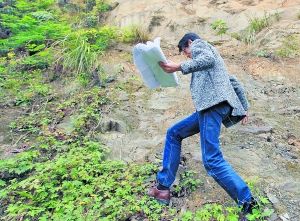
Wang Lin conducts on-site terrain and road surveys in Nanshan.
This designer hiked the Nanshan Mountain nine times to draw its map.
In his nine ascents of Nanshan, he discovered ancient mule caravan routes long vanished; stumbled upon lesser-known mountain delicacies; and even encountered Nanshan scenery that even locals had never seen...
For Wang Lin, a native of Chongqing, Nanshan Mountain is all too familiar. In February this year, Wang Lin participated in the Nan’an District “Call for Top Ten Nanshan Maps” campaign. He packed his backpack, brought dry rations, and made nine trips to Nanshan to conduct on-site research. Drawing from what he saw and heard, he created 13 Nanshan maps covering various aspects such as tourism, food, education, and religious culture.
Perseverance
Dry rations and water for a full day’s hike
Wang Lin, 31, is a designer specializing in urban landscape planning and design. He has worked on projects such as the landscape renovation design of the Great Golden Eagle at Nanshan Botanical Garden and the redesign of Jiefangbei Pedestrian Street.
At the end of last year, the “Call for Top Ten Nanshan Maps” campaign launched by Nan’an District reignited Wang Lin’s passion for design.
Wang Lin decided to revisit Nanshan. Two nights before heading up the mountain, he downloaded over 100 high-definition satellite maps from Baidu and Google Maps, then used software to stitch them together into a single A0-sized high-definition satellite image. On the morning of February 16, Wang Lin set off on his on-site research, camera in hand.
“The first prerequisite for making a travel map is scientific verification; otherwise, you’re just giving people the wrong directions.” Out of professional habit, Wang Lin insists on personally verifying every trail and scenic spot on the map. Once he heads up the mountain, it’s an all-day affair until nightfall.
Wang Lin only brings a backpack when he goes out, containing bread, chicken legs, and water. “I’m out for the whole day, and I sit down to rest for no more than five minutes.” He takes photos, makes records, and asks locals about local customs. He uses all kinds of transportation — buses, tricycles, motorcycles, and fixed-route vans.
Hardship
Nine ascents of Nanshan, rain or shine
During the nine days of research, Wang Lin kept records almost every day.
The first two days had good weather, and Wang Lin’s research went relatively smoothly. But on the third day, it poured heavily.
That day, Wang Lin was exiting Kongyuan, walking along the mountain path toward a farmhouse, and on his way to Wuma Reservoir. The poetic mountain trails and farmhouses along the way captivated him, making him feel as if he had entered a paradise. But unfortunately, the weather turned nasty, and suddenly it started pouring.
The muddy mountain path was treacherous to walk on, and Wang Lin accidentally slipped into the woods. His already painful leg got scratched.
February 19 was described by Wang Lin as “the most painful and terrifying day.” That day, he went to explore the Ba’er Mountain hiking trail. As he walked, he came across a desolate, barely distinguishable path — narrow, steep, lined with scattered graves, and bitterly cold.
Wang Lin proceeded cautiously, gritting his teeth until the end, only to find that the back entrance of the trail had been sealed off. To avoid backtracking, he decided to climb over a wall. To his surprise, on the other side of the wall was Huangming Highway.
A pleasant surprise
He found the mule caravan entrance
The exploration journey also often brought unexpected surprises.
One day, Wang Lin went to Laolong Cave to take photos. As usual, on his way back, he stopped a tricycle driver and bombarded him with questions. Unexpectedly, he met descendants of the mule caravans.
Wang Lin asked the elderly man to drive the tricycle and point out the five mule caravan entrances around the old factory one by one. Among them, the entrance near Yuelan Bridge, which once led directly to Yelang in Guizhou, could no longer be found. Had it not been for the old man’s guidance, this place might have forever disappeared from the map, just as the bustling mule caravans once did.
Discovering a peach blossom forest was also an accident. While practicing driving, Wang Lin passed through Tongluo Gorge and unexpectedly discovered a newly opened Nanshan Peach Blossom Garden. He wandered deep into the peach grove and only snapped out of it when the driving instructor and car were nowhere to be found. He had to spend 40 yuan on a taxi ride home.
Meticulousness
Collecting restaurant phone numbers from door to door
Wang Lin said that this set of maps consists of 13 sheets, and people of different ages and backgrounds can all use them as guides to find their own ways to have fun.
When drawing the map of resistance war relics, Wang Lin agonized for a while over how to annotate the "Cemetery for Anti-Japanese Air Force Soldiers." In the end, he added a few words behind the image: "Final Resting Place of the Flying Tigers' Heroes."
How to create a livable map? Wang Lin didn’t want to simply turn this map into a real estate advertisement. He thought of the numerous elderly apartments scattered across the mountain. After personally visiting them one by one, he eventually marked more than ten relatively large elderly apartments on the map. Truly a case of “longevity rivaling the southern mountains”!
Wang Lin specially made a private car route map for drivers and a Nanshan food map for foodies. For every restaurant on the food map, Wang Lin personally verified the information, collecting phone numbers and specialties. For those without a phone number, he went door-to-door to collect business cards. He divided Nanshan’s cuisine into five areas and gathered the data from each spot, ensuring there were no “fake listings.”
Through more than half a month of ups and downs, Wang Lin’s affection for Nanshan grew bit by bit. “This is something I enjoy doing, and I hope even more people will pay attention to Nanshan and fall in love with it,” said Wang Lin.