Full Story of the Snow Mountain Stranding Incident: Black Forest Snow Makes Path Judgment Difficult
Introduction: Chen Youzhu, Zhang Yunqian, and Liu Dazhi set out to climb a snow mountain together on December 30, 2013. On December 31, Chen Youzhu and Zhang Yunqian failed to return to the mountain hut within the expected time after climbing the peak. The two endured three days and four nights in the freezing high mountains before safely returning to the hut on the afternoon of January 3. Hiking Notes conducted an exclusive interview with the two individuals, detailing this harrowing experience and how they calmly managed to escape and survive. ETtoday News Cloud has been authorized to republish the full account to present the true story.
ByHiking Notes and Mountain Hiking Supply Station
Editor’s Note:Recently, we had a rare opportunity for Hiking Notes and Mountain Hiking Supply Station to interview Chen Youzhu, Zhang Yunqian, and Liu Dazhi—the individuals who got lost in the snow mountains last year. While we were overjoyed for them, we were also curious about how Chen Youzhu and Zhang Yunqian managed to survive three days and four nights in the freezing high mountains.
During the interview, we learned that surviving in such an environment depends not just on luck, but also on equipment, mental strength, and physical fitness—all critical factors. It’s definitely not as simple as what some news reports suggest (like just relying on two Mentos candies, which incidentally weren’t even Mentos). We’re sharing this in hopes it will be helpful and serve as a reminder to others.
Key Individuals Involved
Chen Youzhu (male, 30), Liu Dazhi (male, 27), Zhang Yunqian (female, 41). Chen Youzhu and Liu Dazhi are friends. Zhang Yunqian originally planned to join the trip with a female friend of Chen Youzhu’s, but her friend came down with a cold the day before and decided not to go. As a result, Zhang Yunqian didn’t know Chen Youzhu or Liu Dazhi beforehand—this was their first meeting.
Mountain Climbing Experience of the Three
Chen Youzhu has climbed 10 of Taiwan’s “100 Peaks” and once scaled the snow mountain in summer. Liu Dazhi has hiking experience but no high-altitude mountain experience—this was his first 100 Peak climb. Zhang Yunqian had no hiking or mountain climbing experience and this was also her first 100 Peak climb.
Original Planned Itinerary
Dec 29: Taipei → Wuling Farm
Dec 30: Snow Mountain Trailhead → Snow Mountain East Peak → 369 Mountain Hut
Dec 31: 369 Mountain Hut → Snow Mountain Main Peak → 369 Mountain Hut
Jan 1: 369 Mountain Hut → Snow Mountain Trailhead → Taipei
Actual Itinerary
Day 0 (Dec 29): Taipei → Wuling Farm (overnight stay)
Day 1 (Dec 30): 9:00 AM start from Snow Mountain Trailhead → 6:00 PM arrival at 369 Mountain Hut
Day 2 (Dec 31): Liu Dazhi showed early signs of altitude sickness in the morning and decided to stay at the 369 Hut while waiting for the other two. Chen Youzhu and Zhang Yunqian departed the 369 Mountain Hut at 8:00 AM → around 9:00 AM, they got lost in the Black Forest near the 8.1K mark
Day 3 (Jan 1): Stranded in the Black Forest and West Taoyue Stream (upper reaches of Qijiawan Stream) area
Day 4 (Jan 2): Still stranded in the West Taoyue Stream area
Day 5 (Jan 3): Managed to return to 369 Mountain Hut on their own and escaped danger
Equipment Chen Youzhu and Zhang Yunqian Had When Departing from 369
Chen Youzhu
● Gear:75L large backpack, 12-point crampons, ice axe, trekking poles, GPS, compass, Casio hiking watch (with altimeter), headlamp, mobile phone, Shanghe map (TM06), whistle, thermometer, 2 lighters, Swiss Army knife, large plastic bags, first aid kit (cold medicine, headache pills, stomach medicine, band-aids, triangular bandage, iodine, gauze, Danmushi x7), 2 wet wipes, 2 facial tissues, camera (7D)
● Clothing:OR dome hat, long-sleeve moisture-wicking shirt, fleece mid-layer, down jacket, mont-bell rain jacket, hiking pants (fleece-lined inside, water-resistant outside), wool socks, hiking boots, gaiters, warm gloves, windproof gloves, headscarf, fleece beanie
● Food:Two bread loaves, one pack of beef jerky, one pack of dried mango, three packs of energy drinks (two jelly types and one Energy In), two Black Gary gummy candies, three pieces of chocolate, one large pack of chewing gum, a 3L water bag (containing 2L of water), a 750c.c insulated bottle (filled with hot water)
"Zhang"
● Equipment:Side-slung small backpack, 12-claw crampons, mini flashlight, about 20 sheets of toilet paper, one black shopping bag, lip balm, face cream, EasyCard, compact yellow rain poncho, trekking poles
● Clothing:Beanie, thick fleece underwear, North Face fleece mid-layer, bicycle line wool sweat-wicking cycling jersey, wind/rain jacket, down long coat (travel version, resistant to -0°C), trekking pants (fleece-lined inside, water-resistant outside), wool socks, hiking boots, gaiters, warm gloves
● Food:Four throat lozenges, a small piece of lunch pastry, three thin slices of chocolate, a 600c.c insulated bottle (filled with water at the mountain entrance start point, only a sip left by the day’s end)
How did the four lost days and nights (12/31–01/03) pass?
"12/31" – Weather: clear, ground covered in snow / daytime temperature around 5–10°C, nighttime around 0°C
● "Chen" and "Zhang" set off from 369 Mountain Hut at 8:00, arriving at the signpost at 8.1K in the Black Forest around 9:00. They kept walking but did not see the 8.2K sign, and began encountering fallen trees (Photos 1 & 2). Trying to backtrack also yielded no trace in the snowy terrain, so at that moment, "Chen" suspected they were lost and decided to move upward and left.
● The pair continued ascending the slope and reached the ridge around 12:00. Given the rocky terrain, they later speculated they might have reached the area around Ganmulin Mountain or 3666 Peak, possibly even ascending Ganmulin Mountain (3670m), as their altimeter showed 3700m at the time.
● From the ridge, they could see Snow Mountain Cirque and North Peak Ridge (Photo 3), but no trails or people. They tried whistling but with no success.
● "Chen" wanted to try walking along the ridge toward the cirque, but the wind was extremely strong and the terrain very dangerous (Photo 4). The temperature on the ridge was dangerously low. "Zhang" persuaded "Chen" against it, and the two decided to descend, hoping to find a warmer area. However, considering the difficulty of the path they had come up, they looked for safer, easier spots to descend.
● By 15:30, after descending, the altimeter showed 3100m—lower than 369 Mountain Hut—but they found no signs of any trail or path along the way. At this point, they were certain they couldn’t return to the hut.
● Considering the cold temperature and humidity, which made staying overnight unfavorable, and having heard the sound of a stream, they decided at 16:30 to keep descending and spend the night five meters away from the stream. They reached the camping spot at 20:00.
● The campsite had a slight slope but was generally flat and sheltered from the wind. There were trees and rocks nearby, though it was somewhat damp. They tried to light a fire but couldn’t because the lighter had no fuel. The two sat back-to-back to sleep — "Chen" covered with a large backpack cover, sitting on "Zhang"’s shopping bag; "Zhang" covered his legs with a large plastic bag. To fight the cold, they periodically stood up to move around, so neither slept for more than an hour at a time.
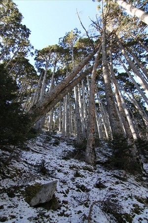
Photo 1: Near the 8.1K getting-lost spot (Photo by Chen Youzhu)
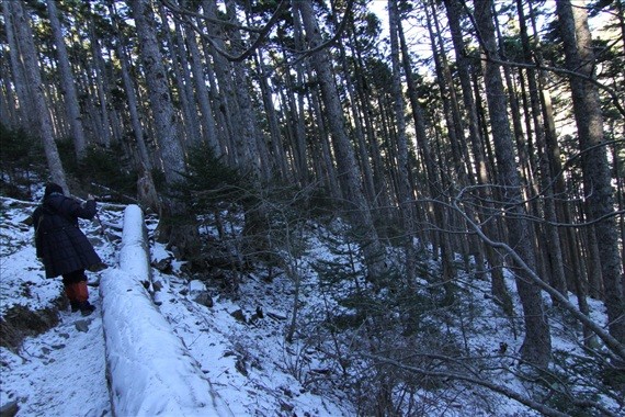
Photo 2: Fallen tree on the trail with multiple trekking pole marks, likely still on the correct path (Photo by Chen Youzhu)
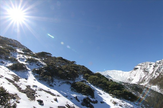
Photo 3: On the way up the ridge after getting lost, North Peak Ridge can be seen (right), along with the cirque and Snow Mountain Main Peak (Photo by Chen Youzhu)

Photo 4: The terrain on the upper ridge mostly consists of large boulders; they later guessed it was around Ganmulin Mountain or 3666 Peak (Photo by Chen Youzhu)
"01/01" – Weather: clear / daytime temperature around 5–10°C, nighttime around 0°C
● Woke at 6:00, got ready and set off at 7:00. Since the previous attempt to ascend the ridge failed, they studied the map and considered the temperature and surroundings before deciding to walk downstream along the creek.
● At 8:20, they saw/heard a helicopter. They used a whistle but with no response.
● They continued along the creek. At one point, both got slightly wet; "Zhang"’s feet, lower body, and backpack were all soaked, while "Chen"’s feet were just a bit damp but otherwise okay. Along the way, "Chen" checked the gear again and found another lighter in the first aid kit — he couldn’t recall when it had been placed there.
● As they descended along the creek, they encountered around four spots where they couldn’t walk directly through, opting instead to bypass via higher ground. Using the map, compass, and altimeter on their hiking watch, they were able to better confirm their general location. Starting at 15:00, they gathered branches along the way, and at 15:30, arrived at a wind-free, relatively flat area about 2500m above sea level not far from the creek, where they decided to camp for the night.
● They used toilet paper as kindling to start a fire. The two rested back-to-back — one watching the fire, the other sleeping, each for no more than an hour. When it got too cold, they would stand up and move around. But the fire only lasted until midnight due to insufficient firewood.
"01/02" – Weather: clear / daytime temperature around 5–10°C, nighttime around 0°C
● Woke at 7:00, got ready and set off. Based on the map, compass, and altimeter, they determined their position was near the Taoshi West Creek (labeled as Qijiawan Creek in Up River Culture TM06) under Snow Mountain East Peak, and decided to begin ascending. "Chen" believed they would definitely reconnect with a trail. Before ascending, he filled the water bag to 3L.
● Knowing that the helicopter might appear around 8:20 AM, they gathered dry firewood and started a smoky fire at 8:00 AM, covering the flames with wet leaves and sand to produce more smoke. Unfortunately, the helicopter still failed to spot them.
● After the helicopter left, they continued ascending through extremely dense arrow bamboo, using ice axes and trekking poles to clear a path. They pushed forward despite occasional cuts on their bodies and spotted several mountain goat droppings along the way.
● At 15:30, they reached an altitude of 2,760 meters and found a tree hollow, deciding to use it as their campsite for the night. With the experience from the previous day, they collected plenty of branches this time, keeping the fire burning for a full 12 hours (from 18:00 to 06:00 on 01/03). The two took turns resting back-to-back and managed to sleep for 1–2 hours that night.
《01/03》Sunny weather / Daytime temperature around 5–10°C, nighttime around 0°C
● At 7:00, they packed up and set off. At 8:00, they tried to start a signal fire but failed (the leaves were too wet). No helicopter was seen that day either.
● They continued ascending toward the direction of Snow Mountain East Peak and spotted the zigzag grass slope behind 369 at 11:30.
● They kept cutting through arrow bamboo and ascending to 3,000 meters, where they saw the 369 Mountain Hut. Since the ascent route passed through a forest, and based on their experience from the past two days, they were concerned about encountering difficult terrain in the woods. They decided to bypass the forest and traverse diagonally back toward the 369 Mountain Hut.
● At 14:00, they arrived at the 369 Mountain Hut and were out of danger.
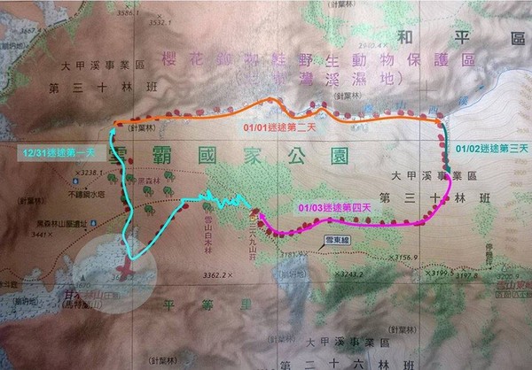
▲ Estimated route of the two lost hikers over four days. (Photo provided by Hiking Notes)
How was food managed?
《12/31》
● Breakfast: Ate at the 369 Mountain Hut. “Chen” had two portions of rice porridge, a can of tuna, and chocolate powder. “Zhang” ate two slices of whole wheat toast and a bowl of vegetarian rice vermicelli soup.
● Lunch: The two shared one bread.
● Dinner: The two only drank water.
《01/01》
● Breakfast: The two shared one bread.
● “Chen” began rationing food. When hungry, each could have up to three black cherry gummies per day. Since “Zhang” was vegetarian, he could have up to one dried mango slice per day. “Chen” would eat some jerky because they were near a stream and never lacked water.
《01/02》 & 《01/03》
● Breakfast: Shared one pack of energy drink. Otherwise, the same rationed food as on 《01/01》.
Insights from the Hiking Notes and Mountain Supply Station after interviewing the hikers about the Snow Mountain getting-lost incident:
After hearing the two hikers’ accounts, we analyzed the entire event. Aside from their incredible luck, there are several key takeaways everyone can learn from.
● Timing (Weather):Although there was snow on the ground, the weather was clear and visibility was excellent throughout these days.
● Terrain:The overnight spots they found were all decent. Except for the first night, which was somewhat damp, the next three nights were all sheltered, flat, windless, and close to water sources.
● Teamwork:The two didn’t know each other well but remained calm and composed. They seldom spoke during the hike and almost never argued. “Chen” never made decisions unilaterally just because “Zhang” lacked mountaineering experience. When discussion was needed, “Chen” would explain the situation first, and they would decide together before acting. “Zhang” respected “Chen’s” decisions throughout and didn’t insist on his own opinions. Aside from staying calm, both had very strong survival instincts and believed they would find a way out.
Both “Chen” and “Zhang” said that if they had been alone, they probably wouldn’t have made it out safely. Their calm response to the situation, mutual support, and use of available information (altitude, map) to figure out the best solution are exemplary for other hikers.
Food:“Chen” had prepared quite a lot of food and managed it rationally. Although they were hungry every day, they managed to endure. In the end, when they returned to 369, they still had a few strips of jerky, one dried mango slice, a pack of gum, an energy drink, and water left.
Gear:A compass and map are truly essential! Although "Chen" had a GPS, it ran out of power quickly due to the low temperature, and he didn’t bring spare batteries. It only successfully turned on once, and even then, the location was incorrect. In the end, it was the most basic yet crucial compass and map, combined with the altitude reading from his hiking watch, that helped him determine his approximate location and eventually get out of trouble. Also, never underestimate the importance of gear just because it’s a day trip. (For gear, see: What to pack in your small backpack?)
Clothing:Although the clothes worn by "Zhang" were not entirely mountaineering gear, they were at least moisture-wicking and warm enough to withstand the cold at night. Both also had waterproof clothing to guard against moisture.
Physical Fitness:Walking non-stop for four days through unmarked trails would be impossible without good physical condition. "Chen" plays badminton once a week and swims on weekends; "Zhang" has practiced qigong for two hours every day since turning 30. These regular exercises helped them maintain excellent fitness, which shows how important working out is!
Learning by Doing:After hearing "Chen"’s account, we couldn’t help but wonder if he had taken a wilderness survival course, as he seemed so knowledgeable. But actually, "Chen" only had two years of high-altitude experience and considered Beidawu Mountain the toughest he’d climbed. He had never taken a survival course either. However, he learned by doing and observed subtle signs — for example, noticing on the first day that throwing wet branches into the fire produced smoke, and then using wet leaves the next day to create a thick smoke signal in hopes a helicopter would spot it. This shows that staying calm and continuously learning from nature are essential lessons every hiker must master.
Analysis and Recommendations on This Getting Lost Incident
●Main Reason for Getting Lost:The black forest area was covered in snow, making it difficult to identify the trail. After passing the 8.1K mark, the pair noticed something unusual (they didn’t see the 8.2K sign and encountered fallen trees blocking the path). Instead of turning back to the 8.1K point immediately, they chose to ascend leftward, which led to their getting lost.
Recommendation: When you realize you’re lost, the first thing to do is always to return to the last confirmed point. If that's not possible, stay put and wait for rescue. Don’t expand the search area or make the situation more difficult.
● On the first day after reaching the ridge, visibility was good, and they could see the main peak, North Ridge Peak, and other mountains. At that point, there was an opportunity to confirm their location.
Recommendation: If you get lost but reach a spot with good visibility, use a map + compass + resection method to determine your position.
● On the first day after descending, they passed through the main route of the black forest, but it’s likely they didn’t notice it due to the dim light under the trees and possibly because it was close to dusk, so they continued downward.
Recommendation: If you want to find your own way, do so only when lighting, weather, and physical conditions allow.
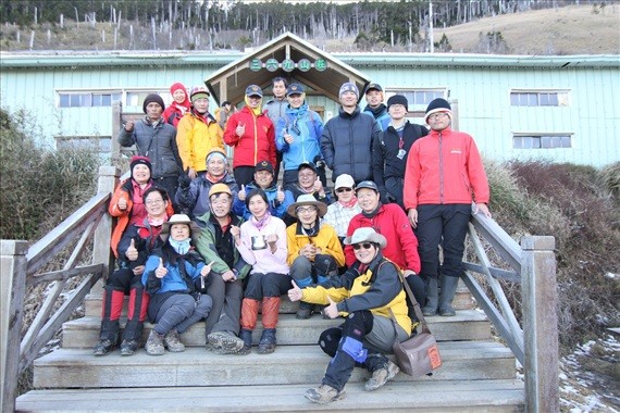
▲ Chen Youzhu (middle, wearing yellow) and Zhang Yunqian (middle, wearing pink) with rescue personnel in photo 369 (photo provided by Chen Youzhu)
The above article is reprinted from"Hiking Notes"
Original URL: http://hiking.thenote.com.tw/article.aspx?id=1b415ca3-1452-43e1-a734-55621003aa7d
Share
This article is published by HowToTrip. Sharing and reposting are welcome — please credit the source.
Article URL: https://www.howtotrip.net/views-25319
Related Articles
- Shaoxing's "Grandpa Gourd" hangs the gourds back up: "If there are too many people, we'll interact less — just take a quick look from afar"
- Chinese authorities announce "reciprocal adjustment" to Japan visa fees — single-entry visa jumps from 2,250 to 16,750 yen!
- The "health stones" carried by a traveler were found to have radiation levels exceeding safety limits by a thousand times, potentially endangering fellow passengers on the same flight. Customs issues warning!
- Shenzhen Airport Issues Late-Night Notice: Unidentified Aerial Object Detected, Causing Widespread Flight Delays!
- “They only said it cost money after I opened the box and washed it!” 200g of grapes sold for 60 yuan on a high-speed train—12306 responds!
- Can't buy an airline ticket? Denied exit? Blocked from boarding? A large number of Chinese tourists have mysteriously become "discredited individuals"
- Adverse weather and economic fluctuations impact Colombia's coffee market
- Beach bathing area responds to 2 yuan/30 seconds fee for freshwater foot rinsing: Clearly priced!
- Taking off with an improperly closed cabin door? Wing malfunction? Multiple flights made emergency returns mid-journey!
- Experience the gifts of nature! A countdown of the world’s ten most stunning coastlines