Brave the Untamed Paradise of Western Sichuan & Unveil the Mysteries of Kangding

Western Sichuan, a land situated at the junction of Yunnan, Sichuan, and Tibet, and the transitional zone between the Chengdu Plain and the Hengduan Plateau, has preserved vast stretches of untouched pristine scenery due to its extreme landforms and high altitudes. This heavenly landscape, akin to paradise, has been hailed as the “last secret realm” by the legendary Japanese mountaineer Yuichiro Miura.
Kangding
Located at the foothills of Paoma Mountain on the northern side of Gongga Mountain, Kangding was once the capital of the former Xikang Province and is today the capital of Garzê Tibetan Autonomous Prefecture. It also marks the boundary between the Han and Tibetan regions in Western Sichuan. From here westward, the altitude rises steeply, and the proportion of Tibetans increases dramatically.
The name “Kangding” originated in the 11th year of the Republic of China (1922), when Li Xialing, the military governor guarding the Sichuan-Tibet border, named it to signify “peace in the Kham region.” Prior to this, Tibetans had always called Kangding “Dazhuzhu,” phonetically similar to “Dajianlu,” meaning “three mountains standing opposite each other, two rivers converging.” “Da” refers to the Daqu River flowing from the earth and mountain, “Zhe” refers to the Zheduo River from Zheduo Mountain, and “Zhu” means the confluence of the two.
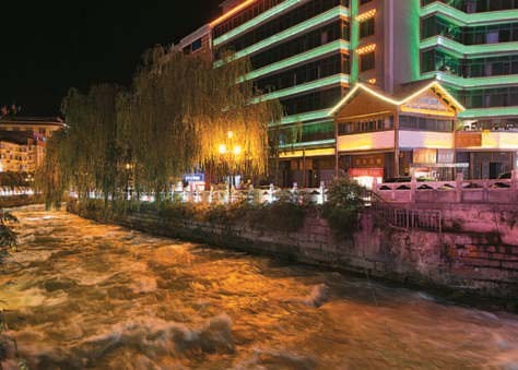
▲ The Zheduo River rushing through the city flows at an extremely fast pace.
From a high vantage point overlooking downtown Kangding, one can see rows of houses densely nestled in the low-lying area where mountain ranges intersect. The Zheduo River flows swiftly along the central axis, giving the urban area a vibrant and lively atmosphere.
A Golden Sandy Beach in the Deep Mountains – Mugecuo
Just 17 kilometers from Kangding, Mugecuo is a highland lake featuring a golden sandy beach. When the sun sets, the lake shimmers with golden hues, and the lakeshore glows brilliantly, creating a dreamlike scene that has earned it the lovely nickname “Love Beach.”
The water of Mugecuo Lake primarily comes from the melting snow of nearby Nuwa Snow Mountain, resulting in crystal-clear water with visibility reaching 6 to 10 meters. Although the lake covers only 3.2 square kilometers — less than half the size of Sun Moon Lake — it is the largest highland lake in Western Sichuan. When gentle waves ripple across the lake surface stirred by mountain winds, it truly gives visitors the surreal illusion of being at a beach in the deep mountains.
▲ A cable car spans over the glacial river, offering sweeping views of the breathtaking scenery.
This area belongs to the middle section of Gongga Mountain, serving as the transition zone between the Sichuan Basin and the Qinghai-Tibet Plateau. The scenic area features diverse landscapes including lakes, forests, grasslands, and hot springs. Travelers can take a vehicle up to Mugecuo at the highest point of the scenic area, then descend sequentially to explore attractions such as Qisehai, Yaochi F boiling springs, and Fangcaoping. The entire hiking journey takes approximately 3 to 4 hours.

▲ The crystal-clear waters of Mugecuo offer visibility of up to 10 meters on sunny days.
For travelers with average hiking abilities, they may also choose to walk only from Mugecuo to Qisehai, an 8-kilometer stretch of scenic canyon that is considered the highlight of the area.
A Playful Prank by Mother Nature – Hailuogou’s Red Stone Beach
Glacial ice fields and sulfur hot springs — one is icy cold, the other steaming hot — yet these two extremes meet remarkably in Hailuogou.
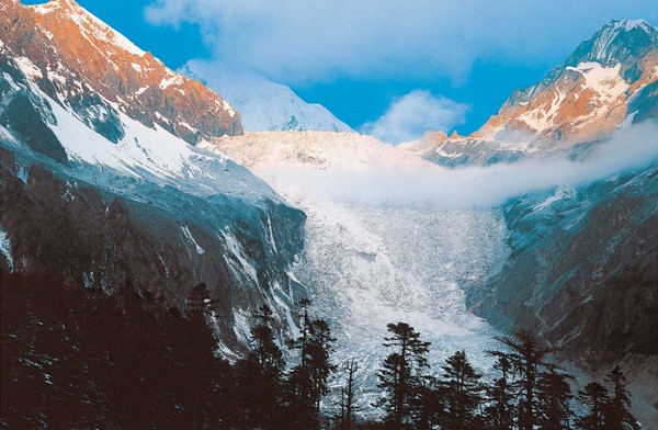
Nestled at the foot of the sacred Gongga Mountain, “Hailuogou” boasts a glacier waterfall that is 1,080 meters high and 1,100 meters wide. Among all known glaciers in China, it is the highest, and one of the few low-altitude glaciers in the world that remains accessible year-round.
As the Hailuogou scenic area was developed relatively early, it now has well-established tourism facilities, with highly convenient accommodation and transportation options. The area includes campsites numbered 1 to 4, with higher numbers closer to the glacier. Campsites 1 to 3 offer lodging, and Campsite 2 even features a hot spring base.
Most travelers choose to stay here for one or two nights before taking a cable car up to Campsite 4 the next day to reach the base of the glacier, experiencing the chilling blast of icy air and even touching the millennia-old frozen icefall.
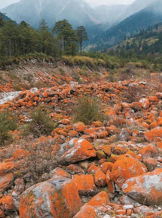
▲ The dazzling bright orange color is absolutely not a post-processing effect.
At the foot of Gongga Mountain in Sichuan, besides the lofty and frigid ancient glaciers, the newly established “China Red Stone Park” in 2013 features a magical scene covered with strikingly bright orange rocks — like a playful prank by Mother Nature.
Siguniang Mountain
Comprising four connected snow-capped peaks, Siguniang Mountain is just over 200 kilometers from Chengdu and is a stunningly beautiful and easily accessible snow mountain and glacier scenic area.
By general Taiwanese standards, the 3,952-meter-high main peak of Yushan already seems out of reach. But looking at the map of the Siguniang Mountain scenic area, within a 500-square-kilometer range (about the size of two Taipei Cities), there are as many as 61 snow peaks over 5,000 meters above sea level, more than 120 icefalls, and countless glacial landforms such as U-shaped valleys, moraine lakes, and horn peaks — earning it the title “Museum of Snow Mountains.”

▲ Siguniang Mountain.
A Feast of Snow Mountains: Shuangqiaogou and Changpinggou
The Siguniang Mountain scenic area currently offers three developed routes: “Shuangqiaogou” is lined with snow peaks, “Changpinggou” boasts diverse vegetation, and “Haizigou” retains its pristine form — each offering distinctly different sceneries. Travelers can flexibly choose electric shuttle buses, horseback riding, or hiking based on their own conditions. Among the three, Shuangqiaogou is the most developed and widely regarded as the route with the most attractions and best views.

▲ The Bonsai Beach in Shuangqiaogou.
The 34.8-kilometer-long route is fully open to vehicles. Travelers can drive directly from the entrance to the deepest attraction — the Redwood Forest — and then explore sites such as Riyue Baojing Mountain, Ye Ren Peak, Eagle Beak Rock, Nianyu Dam, and Sea Buckthorn Forest along a downhill hiking trail.
Although most are dominated by mountain scenery, each peak and vista is distinct. Hiking down the mountain while capturing the views along the way feels like attending a grand exhibition of peaks. Changping Valley, which is moderately developed, is renowned for its rich and diverse vegetation and is a paradise for hiking enthusiasts.
The 29-kilometer trail is about one-third accessible by vehicle, with the rest requiring horseback riding to enter. Riding through vast primeval forests, as the horse moves slowly, you’ll sometimes find yourself shaded by ancient trees with no sunlight in sight, and other times golden rays filtering through the leaves create dappled light on the thick mossy ground, exuding a faint green glow. The fantastical and beautiful scenery resembles the Elven forest of Lothlórien from *The Lord of the Rings*.
A wild and adventurous paradise: Haizi Valley
As for the most pristine Haizi Valley, it is the least developed area in the scenic zone, the shortest in length, yet offers the most raw, vast, and magnificent landscapes. The entire 20.3-kilometer route is not accessible by vehicle, and can only be reached on foot or by horse. This trail is generally less chosen by average visitors.
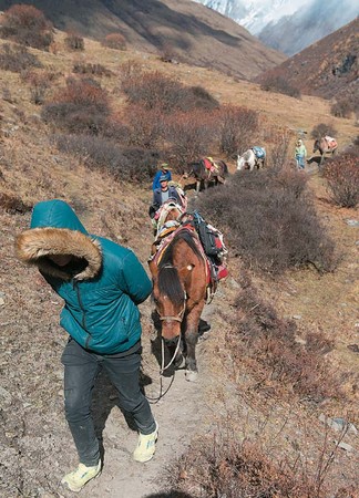
▲ The road to Haizi Valley is primitive and undeveloped.
Haizi Valley gets its name from the more than ten scattered lakes of various sizes within the valley, among which the beautiful Huahai Lake is the most famous. Spanning an area of 10 hectares, Huahai Lake is a... (text truncated)

▲ The glacial erosion barrier lakes in Haizi Valley merge into a vast lake-sea during the rainy season.

Share
This article is published by HowToTrip. Sharing and reposting are welcome — please credit the source.
Article URL: https://www.howtotrip.net/views-10414
Related Articles
- Shaoxing's "Grandpa Gourd" hangs the gourds back up: "If there are too many people, we'll interact less — just take a quick look from afar"
- Chinese authorities announce "reciprocal adjustment" to Japan visa fees — single-entry visa jumps from 2,250 to 16,750 yen!
- The "health stones" carried by a traveler were found to have radiation levels exceeding safety limits by a thousand times, potentially endangering fellow passengers on the same flight. Customs issues warning!
- Shenzhen Airport Issues Late-Night Notice: Unidentified Aerial Object Detected, Causing Widespread Flight Delays!
- “They only said it cost money after I opened the box and washed it!” 200g of grapes sold for 60 yuan on a high-speed train—12306 responds!
- Can't buy an airline ticket? Denied exit? Blocked from boarding? A large number of Chinese tourists have mysteriously become "discredited individuals"
- Adverse weather and economic fluctuations impact Colombia's coffee market
- Beach bathing area responds to 2 yuan/30 seconds fee for freshwater foot rinsing: Clearly priced!
- Taking off with an improperly closed cabin door? Wing malfunction? Multiple flights made emergency returns mid-journey!
- Experience the gifts of nature! A countdown of the world’s ten most stunning coastlines