Essential Kyoto Transportation Guide for First-Timers: Buses, Subways, and JR All in One
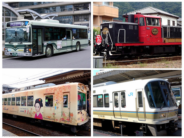
Text & Photos /Unbridled
I always find Japan’s transportation system complicated, with its various names for railways and buses, not to mention the mix of private and public operators—it’s easy to get confused. The same thing happened when I visited Kyoto, but after some research, it actually turned out not to be that difficult. Today, I’ll give you an overview of Kyoto’s transportation, introducing the main public transport options (buses, subways, JR, and private railways) and their routes to help first-time visitors get a general sense of how to get around.
In addition to “buses,” “subways,” and “JR,” Kyoto also has various “private railways.” It may seem complex, but if you understand how to use “buses” and “subways,” you can easily reach most of Kyoto’s attractions. Add in some knowledge of JR’s routes in Kyoto and make use of private railways, and you’ll be unstoppable. Below, I’ll explain the coverage of each of these transport options.
※※Note: This kind of information can be a bit sleep-inducing... but if you can stay focused, read through the details below once, and get a general grasp of the info, you won’t have to worry too much when you’re in Kyoto.
1. Kyoto City Buses
Kyoto has many types of buses, but for tourists,riding the “Kyoto City Bus” (abbreviated as “City Bus,” a public service) is usually enough, so I’ll focus mainly on the “City Bus.”.Before introducing this type of bus, let’s first understand the fare system and how to ride them. (There’s also a privately operated bus called “Kyoto Bus,” whose name can easily be confused with “Kyoto City Bus.”)
● How to Ride:Board from the rear door and exit from the front door.Wait until the bus stops before leaving your seat to exit from the front door.
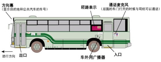
▲ For double-door buses, board from the rear door and exit from the front door (Photo / Kyoto City Information Network)
● Fare Calculation: There are two systems
1.“The “Flat-Rate System”—for buses,“the fare is 230 yen for the entire ride, regardless of distance (120 yen for children)”(except for the 100-yen loop buses).
2. For the “Distance-Based System” buses, the fare is calculated based on the travel distance.
● How to Distinguish Between “Flat-Rate System” and “Distance-Based System” Buses
When boarding from the rear door, check near the“ticket machine for taking a fare slip”. If there is“one,” then it’s a “Distance-Based System” bus.If there is“none,” then it’s a “Flat-Rate System” bus..
● Payment Methods
For the "Uniform System Buses," there is no fare adjustment machine at the boarding point. You can board directly and pay in cash, tap your ICOCA card, or insert your card when getting off through the front door. For card insertion, use the "KTP" or "Kyoto Card" by inserting them upon exiting. As for the "Kyoto City Bus One-Day Pass" and "Kyoto Sightseeing One-Day (Two-Day) Pass," show the date on the back of the card to the driver upon exiting the second time—insert the card upon your first exit.
For the "Adjustment System Buses," when boarding, if you arepaying "in cash," you must "take a fare adjustment slip"; if you have anICOCA card, you must first "tap it once"and then tap it again when getting off; if you have a"City Bus One-Day Pass" or a "Kyoto Sightseeing One-Day (Two-Day) Pass, KTP, or Kyoto Card," you do not need to take a fare adjustment slip, but you must insert your card first, then insert it again at the front door when getting off.
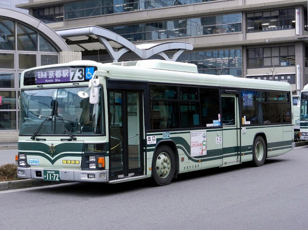
▲ Kyoto City Bus (Image / Wikimedia Commons)
"Kyoto City Bus"(hereafter referred to as"City Bus") is operated by the Kyoto City Government and has over 80 routes.In addition to regular City Bus routes,the "Rakubasu" and the "100-Yen Loop Bus" are also part of the City Bus network.The City Bus routes cover nearly all major sightseeing spots within central Kyoto.
● Rakubasu
The Rakubasu is a "limited express bus" specially set up for tourists' sightseeing needs, running roughly every 30 minutes, connecting major tourist attractions. There are three routes:"Limited Express 100," "Limited Express 101," and "Limited Express 102," all featuring a large "洛" (Raku) character on the bus body.

▲ Rakubasu Logo (Image / Kyoto City Transportation Bureau)
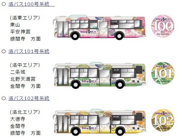
▲ Rakubasu Exterior (Image / Kyoto City Transportation Bureau)
"Route 100"The Rakubasu starts from Kyoto Station, passing through "Kiyomizu-michi, Gojozaka" (near Kiyomizu-dera Temple), "Gion" (Kyoto’s bustling commercial district), "Heian Shrine," "Nanzen-ji Temple," and "Ginkaku-ji Temple."
"Route 101"The Rakubasu also starts from Kyoto Station and stops at attractions such as "Tofuku-ji Temple," "Nijo Castle," "Kitano Tenmangu Shrine," and "Kinkaku-ji Temple."
"Route 102"The Rakubasu passes through "Kitano Tenmangu Shrine," "Kinkaku-ji Temple," "Ginkaku-ji Temple," and "Kyoto Imperial Palace."
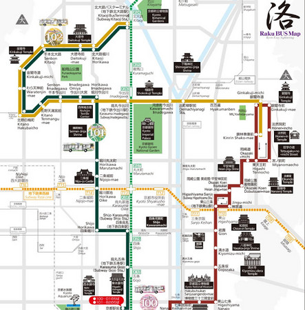
▲ Rakubasu Route Map (Image /Kyoto City Transportation Bureau, click here to download))
●100 Yen Loop Bus
This type of city bushas a large “100Q?弊盅?” on the front.It runs through four bustling main streets in central Kyoto: “Kawaramachi-dori,” “Karasuma-dori,” “Nishiki-dori,” and “Shijo-dori.”The fare is a flat 100 yen, just as the name suggests.
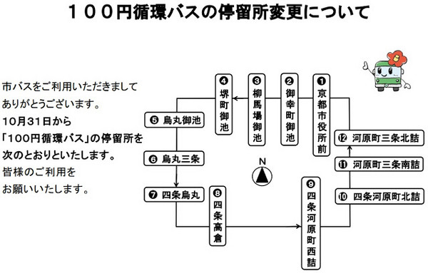
▲100 Yen Loop Bus Route Map (Image /Kyoto City Transportation Bureau, click here to download)
Below is the “City Buses and Subway Sightseeing Route Map.”

▲Kyoto City Bus & Subway Sightseeing Route Map (Image /Kyoto City Transportation Bureau official website, click here to download the map)
Every time I see a densely packed route map like the one above, my brain goes blank and I can’t be bothered to figure it out, so the above can serve as a secondary reference.For friends who, like me, are too lazy to study that complicated route map, you can prioritize the following simple and easy-to-understand transportation table when visiting major attractions in Kyoto (recommended)!

▲Kyoto City Bus & Subway Sightseeing Route Transportation Table (Image /Kyoto City Transportation Bureau official website, click here to download the map)
II. Subway (Municipal Subway, referred to as “Subway”)

▲Kyoto Subway Map (Image /Kyoto City Transportation Bureau official website, click here to download the map)
Compared to the complex bus routes, Kyoto’s subway has only two lines running in a cross pattern.The north-south blue-green line is the “Karasuma Line,” and the red line above is the “Tozai Line.”
How to ride the Kyoto Subway: Just like taking a metro normally, you can use an ICOCA or SUICA (Suica Card), or buy a single ticket. Based on my experience, using a card is definitely the most convenient option.
Kyoto Subway fares: start from 210 yen, up to a maximum of 340 yen.
Sightseeing spots along the route: “Karasuma Oike” and “Shijo” stations are both located in Kyoto’s most bustling shopping and commercial districts. From these two stations, you can also walk to “Kawaramachi” and “Nishiki.” “Nijojo-mae” station is right in front of the famous “Nijo Castle.” From “Higashiyama” station, you can walk to “Heian Shrine”... and more.
If your destination is near a subway station, then taking the subway is naturally very convenient. However,if your destination can be reached by both subway and bus, it depends on how pressed for time you are. Sometimes during rush hour in the city, buses stop frequently and can take quite a bit of time, so taking the subway saves more time. But if you’ve bought a one-day bus pass, then it’s up to you to decide which is better.
III. JR

The image belowLight blue routeisthe JR line passing through Kyoto,which you generally won’t use much within central Kyoto, but will rely on in two scenarios:
1.Traveling to other city areassuch as Osaka, Uji, Nara, Kobe, etc.
2.Visiting the suburbs of Kyotolike “Tofuku-ji,” “Fushimi Inari” (Inari Station – this is the famous filming location from *Memoirs of a Geisha*, featuring endless torii gates), “Arashiyama,” “Lake Biwa,” “Omihachiman,” and others.

▲ Kyoto Metro and JR Route Map (Image /For Kansai Airport transportation info, you can download the full map by clicking here)
IV. Various Private Railways (Private Rail)
In addition to the public JR and Shinkansen railways, Japan has many private railways that can seem quite complex. After reviewing the above introduction to the Kyoto Metro and JR, let’s now take a step further and get an overview of the various private railway route maps. Once you have a general understanding, combining them with bus routes will make you unstoppable.
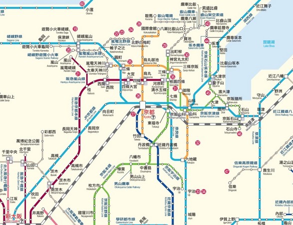
▲ Kyoto Metro, JR, and Private Railway Route Map. This image is a cropped section of the “Kansai Railway Network” focusing on Kyoto. You can click the image to view and download it directly (Image / Kansai Airport Transportation Info. For the “Full Kansai Railway Network Map”you can download it by clicking here)
The “black-and-white striped route” is the “Shinkansen”
The “orange route”isthe “Kyoto Metro”
The “light blue route”is“JR”
the “magenta route”isthe “Hankyu Railway”
The “green route”isthe “Keihan Railway”
The “dark blue route”for"Kintetsu Railway" (abbreviated as "Kintetsu")
"the gray route"The upper left section near Arashiyama is"Arashiyama Electric Railway" (also known as "Keifuku Electric Railway") and "Sagano Sightseeing Railway"(Arashiyama Train), while the upper right section near Kurama is "S..." (text cut off).
※ The following explanation is best viewed in conjunction with the route map above for greater clarity.
1. Hankyu Railway
The deep purple route of Hankyu Railway connects "Kobe, Osaka, and Kyoto." In Kyoto, it stops at "Kawaramachi," "Karasuma," "Omiya," "Seian," and "Arashiyama."
2. Keihan Railway
The green route of Keihan Railway, as the name suggests, runs between "Osaka and Kyoto." In Kyoto, it passes attractions such as "Tofuku-ji," "Fushimi Inari Taisha," "Gion-Shijo (Kyoto’s bustling district)," and "Kiyomizu-dera," and also extends to "Uji" located to the south of Kyoto. The terminal station of the Keihan Main Line, "Demachiyanagi," connects with the "S..." (text cut off).
3. Randen (Keifuku Electric Railway)
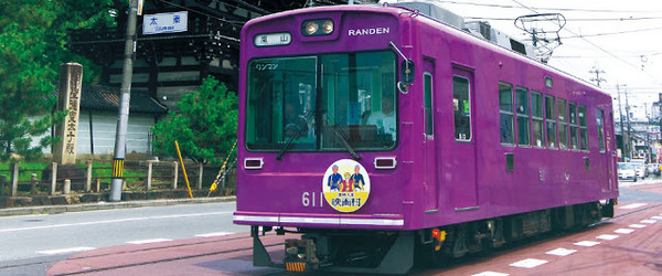
Mainly running between Arashiyama, Shijo Omiya, and Kitano Hakubaicho, the charming and retro-looking Randen is Kyoto’s only remaining streetcar and has been in operation for over a hundred years.
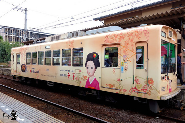
▲% The red line is the only streetcar line in Kyoto that runs on (text unclear if continued from source).
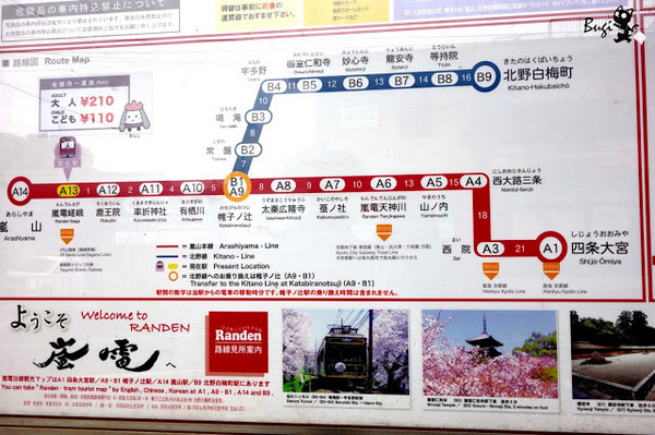
▲ Randen Route Map
Regardless of distance, Randen charges a flat fare of 210 yen for adults (110 yen for children). It passes attractions such as "Arashiyama," "Rakuhoku-in," "Tenryu-ji" (Arashiyama Station), "Ryoan-ji," "Ninna-ji," "Toei Uzumasa Eigamura" (Uzumasa Taishakuten Station), and is also not far from "Kinkaku-ji" and "Kitano Tenmangu."
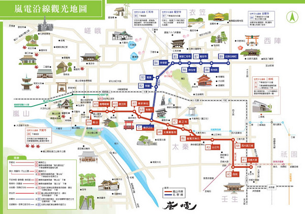
▲ Randen Sightseeing Route Map (Image / Randen Official Website, click here to download)
Randen Official Website:http://randen.keifuku.co.jp/tw/
4. Sagano Sightseeing Railway (Arashiyama Train)
This sightseeing railway is the very line that Taiwanese visitors to Arashiyama in Kyoto love to ride—the"Arashiyama Train."The route offers beautiful scenery year-round, and especially stunning autumn foliage in the fall. The railway follows the Hozugawa River,with only four stations in total from "Kameoka" to "Sagano," and the entire journey takes just 25 minutes. Trains run hourly, with an adult one-way fare of 620 yen (310 yen for children).. Later, I will also write a dedicated introduction to the Arashiyama Train—stay tuned for more details Up!
Sagano Train Official Website:https://www.sagano-kanko.co.jp/chinese.php.
5. S... (text cut off)
The S... (text cut off) connects to stations such as "Amanohashidate," "Ine," "Arima Onsen," and "Kinosaki Onsen." Generally speaking, most of its routes are relatively closer to "Amanohashidate," "Arima Onsen," and other destinations, and thus somewhat less convenient for accessing "Kinosaki Onsen."
6. Kintetsu Railway (Kintetsu)
Basically, Kintetsu does not pass through any major famous attractions in Kyoto, but you can take it if you are heading to Nara.
Finally, here's the "Kansai Railway Network Map" for you to download:
1. Complete Version of the Kansai Railway Network Map.
2.Osaka, Kyoto, Kobe Railway Map.
If you’ve made it this far, you really do have patience XD!But it also means you probably now have a general understanding of Kyoto’s transportation. I hope this information is helpful. Feel free to point out any errors or suggest additions—your feedback is welcome!
Want to see moreuntamed solo travel experiences?
Welcome to jointhe Untamed Fan Pageandthe Untamed Blog.
Feeling bored at work or school and really want to travel?
Download the “ETtoday News Cloud APP” and take a virtual trip with us →
iOS:https://goo.gl/rmIDdx
Android:https://goo.gl/XPe8Uj
Share
This article is published by HowToTrip. Sharing and reposting are welcome — please credit the source.
Article URL: https://www.howtotrip.net/views-8904
Related Articles
- Shaoxing's "Grandpa Gourd" hangs the gourds back up: "If there are too many people, we'll interact less — just take a quick look from afar"
- Chinese authorities announce "reciprocal adjustment" to Japan visa fees — single-entry visa jumps from 2,250 to 16,750 yen!
- 旅客携带的“保健石”核辐射超标千倍,同机人员或遭殃!海关提醒!
- 深圳机场深夜通报!出现不明升空物,航班大面积延误!
- “拆盒洗了才说要钱!”高铁200克葡萄卖60元,12306回应!
- 买不了机票?出境被拒?登机被拦?一大波中国游客莫名成了“失信人”
- 不利天气和经济波动影响哥伦比亚咖啡市场
- 海边浴场回应冲脚淡水收费2元/30秒:明码标价!
- 舱门没关好就起飞?机翼出现问题?多个航班途中紧急折返!
- 感受大自然的馈赠!盘点世界十大唯美海岸线