Cameroon
Known as a microcosm of Africa, this Central-West African nation is famed for Mount Cameroon, volcanic black-sand beaches, equatorial rainforests, and the diverse culture of the Bamum Kingdom.
Cameroon (Republic of Cameroon)
| Capital | Yaoundé |
|---|---|
| Continent | Africa |
| Languages | French, English |
| Currency | Central African CFA franc (XAF FCFA) |
| Time Zone | UTC+1 |
| Dialling Code | +237 |
| Area / Population | 475,400 square kilometers / Approximately 28 million |
| Visa | Most foreign visitors need a visa to enter Cameroon. An e-Visa can be applied for online through the official Cameroonian government platform, or visas can be obtained by applying at the Cameroonian embassy or consulate in your own country. Required documents typically include an invitation letter, hotel reservation, and proof of return or onward travel such as a round-trip flight ticket. Visa policies can change, so check the latest information from Cameroonian immigration authorities or your nearest embassy or consulate before you travel. |
| Best Season | The dry season runs from November to March, when most of the country enjoys drier and cooler weather, making it the best time to visit northern national parks and go hiking. The southern rainforest region is hot and humid year-round, with heavier rainfall from March to November—bring rain gear when traveling during this period. |
| Main Cities | Yaoundé, Douala, Limbe, Kribi, Buea, Bamenda, Bafoussam, Mount Cameroon, Waza National Park |
Cameroon in Detail
Overview of Cameroon
Cameroon (officially the Republic of Cameroon) is located on the northeastern coast of the Gulf of Guinea in Central-Western Africa. It borders Nigeria to the west, the Central African Republic and Chad to the east, and the Republic of the Congo, Gabon, and Equatorial Guinea to the south. The country covers an area of approximately 475,400 square kilometers. Known as “Africa in miniature,” Cameroon features a wide range of landscapes—from tropical rainforests and savannas to deserts and volcanoes—and is home to hundreds of ethnic groups, reflecting much of the continent’s diversity. Its capital, Yaoundé, located on a plateau in the central-southern part of the country, is the political center, while Douala, the largest city on the southwestern coast, is the economic hub and main port.
Cameroon is a presidential republic with French and English as its official languages. There are also over 200 local languages, including Fulfulde and Bamileke. The country is divided into ten regions, with the Northwest and Southwest regions being English-speaking and historically and institutionally distinct from the predominantly French-speaking areas.
Geography and Climate
Cameroon’s geography changes considerably from north to south: the western part includes the Cameroon Volcanic Line, where Mount Cameroon (also known as Fako), at around 4,040 meters, is the highest peak in West Africa and an active volcano. The central region is the Adamawa Plateau, while the north gradually becomes flatter, forming semi-arid and savanna zones near Lake Chad, which include national parks such as Waza. The southern and southeastern parts are covered by equatorial rainforests with high rainfall throughout the year.
The climate ranges from tropical rainforest in the south to tropical savanna in the north. The south is hot and humid year-round, with a long rainy season and high annual precipitation, while the north has distinct dry and wet seasons, with the dry season lasting from November to March. Coastal areas such as Douala and Limbe receive heavy rainfall, and the southern foothills of Mount Cameroon are among the wettest places on Earth. The best time to visit is during the dry season from November to March.
Historical Background
Cameroon’s coastal regions have been in contact with European traders since the 15th century. In 1472, Portuguese sailors named the area’s river mouth “Rio dos Camarões” (River of Shrimp) because of the abundance of shrimp, which later led to the name Cameroon. By the late 19th century, the area became a German colony. After World War I, the League of Nations divided it into British and French mandates.
French Cameroon gained independence in 1960. In 1961, the northern part of British Cameroon chose to join Nigeria, while the southern part joined French Cameroon to form the Federal Republic of Cameroon. It became the United Republic of Cameroon in 1972, then the Republic of Cameroon in 1984. Paul Biya has been president since 1982. Since 2016, the Northwest and Southwest English-speaking regions have seen ongoing conflicts related to language and institutional recognition, and the security situation in those areas remains a concern.
Economy and Currency
Cameroon is one of the largest economies in the Central African Economic and Monetary Community (CEMAC). Its economy depends on oil, timber, agriculture, and port logistics. Major exports include cocoa, coffee, cotton, bananas, and rubber. The Port of Douala is the most important trade hub in Central Africa and handles significant transit cargo for landlocked neighboring countries.
The official currency is the Central African CFA franc (XAF, symbol FCFA), issued by the Bank of Central African States. It is pegged to the euro at a fixed rate of approximately 655.957 CFA francs per euro. The CFA franc is used in all six CEMAC countries, so travelers do not need to exchange money when moving between Cameroon and countries such as Gabon, the Republic of the Congo, or the Central African Republic.
Culture and Society
Cameroon is home to more than 250 ethnic groups, each with its own traditions, including the Bamileke, Fulani, Bamum, and Douala peoples. Foumban in the west is the former capital of the Bamum Kingdom, and its royal palace and museum feature traditional masks, carvings, and artifacts that reflect the area’s rich heritage. Music and football play important roles in daily life, with local music styles like makossa and bikutsi being popular across Central-West Africa.
The staple foods include cassava, plantains, corn, and rice. A popular dish is ndolé (a stew made with bitter leaves, peanut sauce, and sometimes shrimp or meat, usually served with rice or cassava dumplings). Grilled fish (poisson braisé) with spicy sauce and plantains in Douala is also highly recommended. In urban areas, breakfast often includes French bread and coffee.
Tourism Overview
Cameroon offers a mix of natural and cultural experiences: Limbe in the south has volcanic black-sand beaches and a botanical garden with views of Mount Cameroon; the 4,040-meter-high Mount Cameroon, the tallest peak in West Africa, is a popular spot for multi-day treks; Waza National Park in the north, near the Sahel, is home to elephants, giraffes, and antelopes; the royal palaces in Foumban and the Bafoussam area highlight Bamum and Bamileke cultures; and Yaoundé and the port city of Douala offer urban attractions, markets, and cuisine.
Safety Note: Armed conflict and civil unrest have been ongoing in Cameroon’s Northwest and Southwest English-speaking regions since 2016. Official sources have issued repeated safety advisories recommending against travel to these areas. The far-northern region near Lake Chad and the Nigerian border also carries risks from extremist activity and should be avoided. Travelers are encouraged to visit more stable areas such as Yaoundé, Douala, and Kribi, as well as well-established destinations in the west and north. If you plan to visit Limbe, Buea, or other parts of the Southwest English-speaking region, check the current local security situation and follow official advice. Before your trip, review the latest travel advisories, get travel insurance that covers emergency medical treatment and evacuation, avoid travelling at night between regions, and steer clear of large public gatherings.
Local Currency: Central African CFA franc (XAF)
Currency Overview
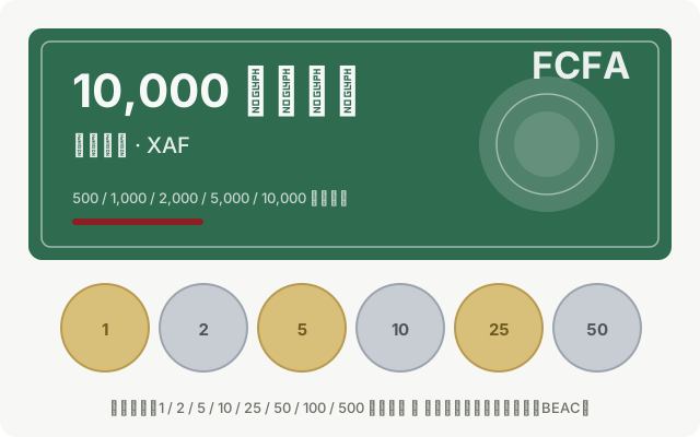
Cameroon uses the Central African CFA franc (Franc CFA, currency code XAF, symbol FCFA), issued by the Bank of Central African States. The CFA franc is the common currency of six CEMAC member states, including Cameroon, Gabon, the Republic of the Congo, Equatorial Guinea, the Central African Republic, and Chad. It is pegged to the euro at a fixed rate of approximately 655.957 CFA francs per euro, helping maintain currency stability. As the largest economy in the CEMAC region, Cameroon sees the highest circulation of the CFA franc, and Douala serves as an important trade and financial centre in the area.
Denominations
Banknotes currently in use come in denominations of 500, 1,000, 2,000, 5,000, and 10,000 CFA francs. The designs reflect regional cultural elements and economic themes, along with the logo of the Bank of Central African States. Newer editions have been released in recent years. Coins are available in denominations of 1, 5, 10, 25, 50, 100, and 500 CFA francs, although smaller coins are less frequently used in everyday transactions.
Cash and Payment Practices
Cameroon is largely a cash-based society. Markets, street vendors, taxis, and rural areas generally only accept cash. Credit and debit cards are accepted in some hotels, shopping malls, and restaurants in Douala and Yaoundé, but their use is limited. Visa and Mastercard may work at certain ATMs in major cities, but you might encounter network issues or additional fees. Mobile payment systems such as MTN MoMo and Orange Money are commonly used by locals but are not widely accessible to foreign visitors.
It is advisable to carry euros or U.S. dollars in cash and exchange them for CFA francs at banks or authorized currency exchange offices in Douala and Yaoundé, and to keep your exchange receipts. The CFA franc is accepted in all CEMAC countries, so no further currency exchange is needed when travelling within the region.
Traveler Tips
- The CFA franc is pegged to the euro, but US dollars are the practical alternative. Bring euros or U.S. dollars for currency exchange locally.
- The CFA franc is shared with other Central African nations such as Gabon and the Republic of the Congo, so you won’t need to exchange money when crossing borders within the CEMAC region.
- ATMs are mostly available in Douala and Yaoundé; it’s a good idea to withdraw enough cash when you arrive in these cities.
- Avoid changing money with street vendors due to higher risk; use banks or authorized exchange services and always request a receipt.
Flag Meaning
Flag Design
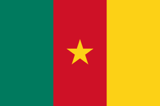
The flag of Cameroon consists of three vertical bands of equal width in green, red, and yellow, from left to right. A yellow five-pointed star is centered in the middle red band. The flag has a 2:3 aspect ratio. The symmetrical and striking design features the central red band with the yellow star aligned perfectly atop it, creating a simple yet highly recognizable tricolor flag.
Meaning
Green symbolizes the southern tropical rainforests and agriculture, as well as hope for a better future. Red represents the blood shed for independence and unity, as well as national sovereignty and solidarity. Yellow stands for the sun, savannas, and natural resources of the north, signifying prosperity and the happiness of the people. The central yellow star symbolizes national unity and the cohesion of all ethnic groups, echoing the color of the yellow band and representing unity as the core of the nation’s wealth. The green, yellow, and red colors are also pan-African colors, reflecting Cameroon’s cultural ties to the African continent and its identity as a country with both English-speaking and French-speaking regions.
History and Legal Status
The current flag was adopted after the merger of the British Southern Cameroons and French Cameroun to form the Federal Republic of Cameroon in 1961. Initially, it featured three vertical green, red, and yellow bands with two stars, representing the union of the former British and French territories. In 1972, when the country became the United Republic of Cameroon, the design was simplified to a single central yellow star. It was retained when the country was renamed the Republic of Cameroon in 1984. The flag’s design reflects the unification of historically distinct colonial regions under a unified national identity and is widely used on national holidays, at government buildings, and during sporting events. May 20 is Cameroon’s National Day.
Cameroon Travel Guide
All Guides »Cameroon Travel Quick Guide: Visa, Best Time to Visit, Budget & Safety Tips
How to apply for an e-visa, the best time to go, daily costs, and how to assess ...
Cameroon 7-Day Classic Route: Douala – Kribi – Yaoundé – Bafoussam and Foumban Ancient Capitals 7 days
From a port city to volcanic ash coasts and inland highlands, then into the anci...
Cameroon 4-Day Short Trip Itinerary: Douala, Kribi, and Yaoundé 4 days
Using Douala as a gateway, this route takes you to the coastal town of Kribi and...
Recommended list of must-visit attractions in Cameroon: black sand beaches, volcanoes, and the ancient capital of the Bamum Kingdom
Explore Cameroon’s top attractions and experiences by region, covering beaches, ...
The Ultimate Guide to Cameroonian Cuisine: National Dish Ndolé, Grilled Fish & Highland Home Cooking
From the national dish ndolé to grilled fish in Douala, cassava fritters to stre...
The Complete Guide to Transportation in Cameroon: Airport Transfers, Taxis, Intercity Buses, and Trains
Getting to and from Douala and Yaoundé airports, yellow taxis and motorcycle tax...
10 Practical Travel Tips for Cameroon: Safety, Health, and Travel Details
From safety conditions in English-speaking and Far North regions, vaccination re...